Monday, August 31, 2026

Operations at Kintla Lake are finished

Glacier National Park posted this on their social media yesterday:
All construction at Kintla Lake is complete! Efforts to plug the historic Butte Oil Well at Kintla Lake this summer were successful, removing safety and health hazards from the area.

Prior to the establishment of Glacier National Park in 1910, mines were developed in the area. One of these sites was at Kintla Lake, which became Montana’s first oil well in 1901. However, soon after its establishment, the historic well caught fire and was abandoned.

In 2023, natural gases were detected to be leaking from the Butte Oil Well. The area is seismically active; tremors and changing pressures within the bedrock often lead to gas escapes. Such conditions present a health and safety hazard.

Plugging the well was considered essential to reduce methane leaks, prevent the migration of chemicals into the lake, minimize physical hazards, and ensure adherence to environmental regulations. Contractors worked with park staff in July and August to plug and cap the well.

Operations at Kintla Lake have now returned to normal for the Kintla Lake frontcountry campground, the Kintla Lake wilderness campground, and trails in the area. Thanks to all who worked on this project, making the Kintla area safer and healthy for all!


              ************************************************************************************

Check out our online trail guides:



Sunday, August 30, 2026

Public Assistance Requested to Account for Individuals Following Grand Canyon Flash Flood

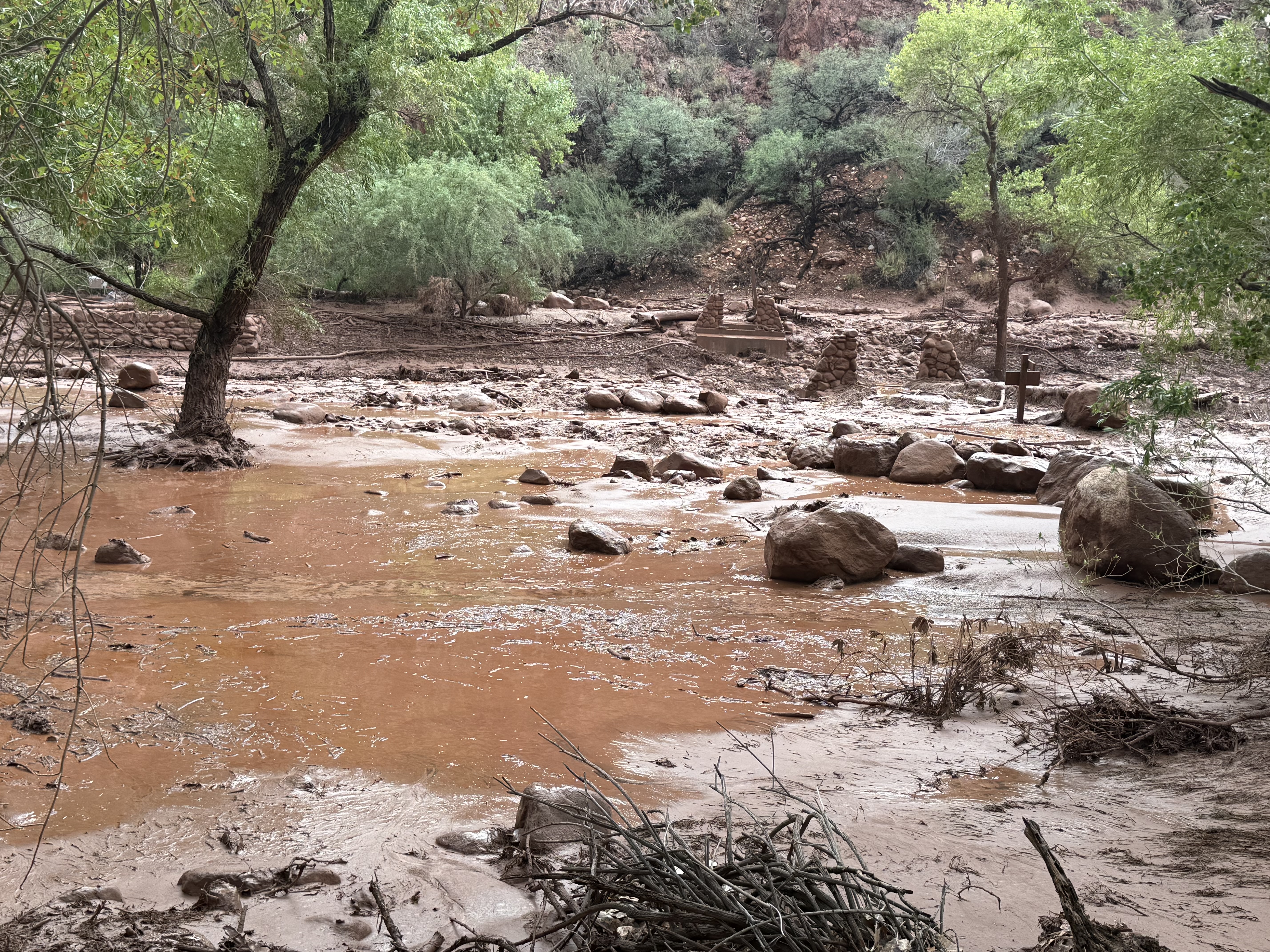
The National Park Service is asking the public to provide information for more than 20 individuals who may be missing or unaccounted for following a significant flash-flood event in Bright Angel Canyon and the Phantom Ranch area on August 29.

Grand Canyon National Park staff, in coordination with the Arizona Department of Public Safety, are continuing evacuation and response efforts and working to account for individuals who may have been in the affected area.

The National Park Service is asking anyone who knows of hikers or backpackers who were in the inner canyon along the Bright Angel Creek corridor on August 29, as well as anyone who had a campground reservation in the affected corridor, to provide information to the National Park Service Investigative Services Branch (ISB). This includes individuals who may have been traveling along the North Kaibab Trail from the North Kaibab Trailhead to Phantom Ranch, staying at Bright Angel Campground, or traveling or staying in the area known as “the Box” north of Phantom Ranch.

If you know of anyone who may have been hiking or backpacking in these areas, please contact the NPS Investigative Services Branch Tip Line:

NPS ISB Tip Line: 888-653-0009

Email: e-mail us

When submitting a tip, please provide any information you have about the individual, including their name, approximate location, travel plans, group size, clothing or backpack description, or when they were last known to be in the area. You do not have to provide your name.

Additional info:

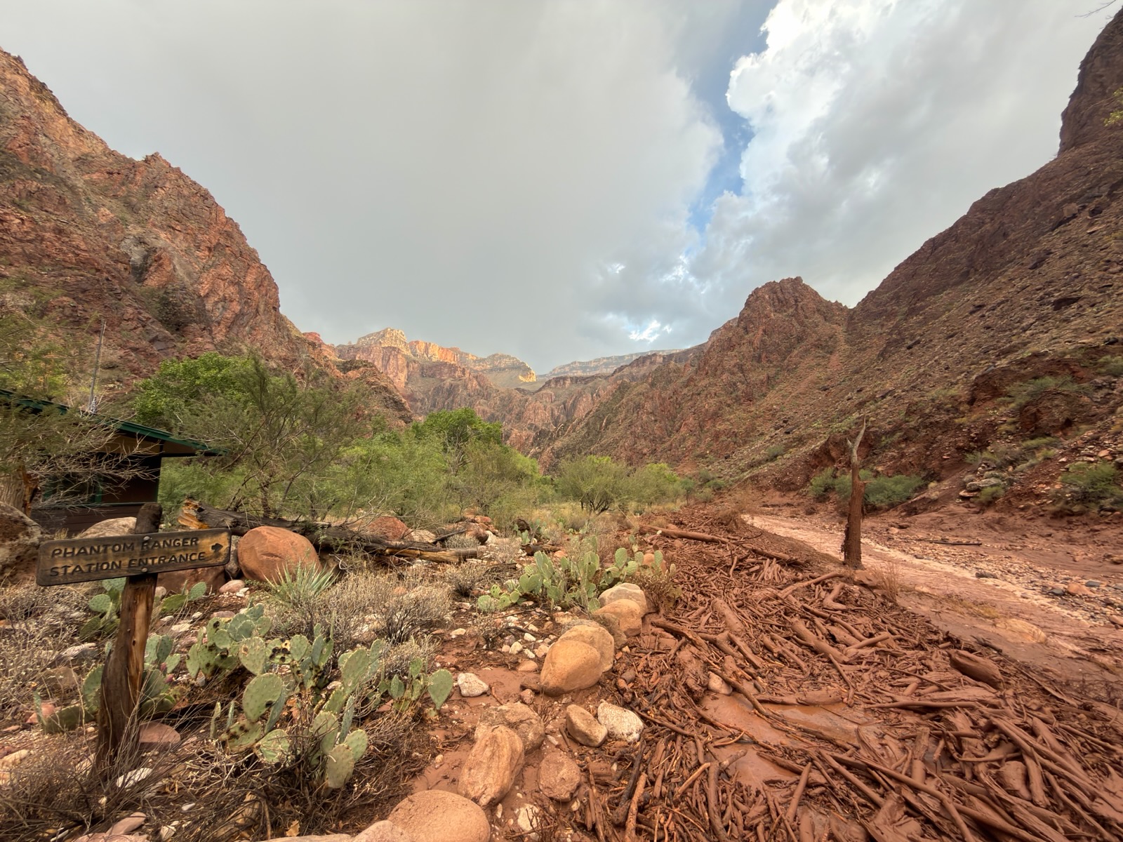
A significant flash-flood event occurred in Bright Angel Canyon and the Phantom Ranch area on August 29, beginning at approximately 2:30 p.m.

As of the morning of August 30, 62 individuals have been evacuated from Phantom Ranch and the lower North Kaibab Trail. Additional individuals are scheduled to be evacuated this morning from Cottonwood Campground and Phantom Ranch in coordination with the National Park Service and Arizona Department of Public Safety. Evacuees are being transported to the Maswik Lodge Cafeteria on the South Rim, where the American Red Cross is coordinating assistance. No injuries have been reported as of the latest available information.
Phantom Ranch, Bright Angel Campground, the Phantom Ranch Canteen and cabins, and the entire North Kaibab Trail from the North Kaibab Trailhead to Phantom Ranch are closed until further notice. The Black Bridge and Silver Bridge crossing the Colorado River are also closed until further notice. There is currently no estimated reopening date for these areas and other inner canyon closures may be necessary. For the latest trail and closure information, visit the park's Key Hiking Messages webpage.

The flash flood resulted in significant impacts to infrastructure throughout Bright Angel Canyon. Nearly all footbridges spanning Bright Angel Creek were destroyed, eliminating hiker access across the creek. Grand Canyon National Park staff are continuing to assess damage to trails, bridges, utilities, facilities and other infrastructure.

The Colorado River is currently closed to river traffic until further notice due to metal structures and debris entering the river. River parties already in the canyon are receiving direction through river operations rangers and the Grand Canyon River Alert system. Visitors with upcoming river trips should contact their commercial outfitter or NPS River Permits for trip-specific information.

Additional thunderstorms and heavy rainfall are possible today and Monday, which could result in additional flash flooding, debris flows, rockfall and changing trail and river conditions.


              ************************************************************************************

Check out our online trail guides:


U.S. Forest Service and National Forest Foundation launch the first National Forests and Grasslands Passport

The U.S. Forest Service and the National Forest Foundation (NFF) announced the launch of the National Forests and Grasslands Passport, a free digital experience designed to inspire visitors to discover more of America’s national forests and grasslands while earning commemorative digital badges along the way.

Available through the OuterSpatial mobile app, the National Forests and Grasslands Passport transforms every visit into a rewarding experience, allowing visitors to check in and earn exclusive digital badges for each national forest and national grassland they explore.

“As an avid fan of the National Park Service Passport Program, I am excited to announce the introduction of the digital U.S. Forest Service Passport Program. More than 164 million people visit our 154 national forests and 20 national grasslands each year bringing back with them stories, family memories and oftentimes plans to return or explore a new Forest Service destination,” said Forest Service Chief Tom Schultz. “Now, millions of people are able to track their visits on their mobile devices through the National Forests and Grasslands Passport, and we are so excited to welcome the next generation of adventurers through this engaging, digital experience.”

Each national forest and grassland has its own specially designed badge, inspired by the iconic Forest Service entrance signs that have welcomed visitors for generations. The artwork reflects the landscapes, wildlife, plants, and other features that define each forest and grassland, creating a collection as distinctive as the places themselves.

Additionally, users will be able to view their total visit number ranked in a leaderboard with other challengers. Visitors are encouraged to log in all their past visits to unlock digital badges to build their own personal collection; however, only check-ins within the geographic coordinates of the national forest or grassland will earn a certified green checkmark.

To learn more about the National Forests and Grasslands Passport and to download, visit: www.nationalforests.org/passport


              ************************************************************************************

Check out our online trail guides:


Friday, August 28, 2026

Glacier National Park Invites Volunteers to 2026 Annual Hawk Watch Events

Glacier National Park will host volunteer training for its annual Hawk Watch Program on Sept. 21 and Hawk Watch Open House on Oct. 3.

Each year in the fall, golden eagles migrate from northern breeding grounds to warmer climates for the winter. One of the most important North American golden eagle migration routes passes directly through Glacier National Park. Large numbers of other raptors also use this migration corridor during the fall and spring months.

In the mid-1990s, biologists documented nearly 2,000 golden eagles migrating past Mount Brown annually. Recent data from outside Glacier National Park indicated significant declines in golden eagle numbers. Due to this concern, the park initiated a Raptor Migration Project in 2011 to investigate possible locations for a Hawk Watch site. In 2018, the park settled on Mount Brown and Lake McDonald sites due to consistent counts of migrating raptors and relative ease of access.

There are two events volunteers can sign up for. The Sept. 21 training will be an in-the-field training day for volunteers interested in participating in the Lake McDonald Lodge Hawk Watch during the end of September through October.

When: Noon to 4 p.m.
Where: Interpretive sign by Jammer Joe’s parking lot
Bring: Binoculars

Once trained and registered for the program, volunteers will help participate in raptor migration counts at Lake McDonald Lodge.

On Oct. 3, the park is hosting the Annual Mount Brown Hawk Watch Open House, which will feature live raptors from noon to 2 p.m. — providing a close-up of raptor species that migrate past Mount Brown. Park biologists will teach volunteers how to identify and count migrating raptors and answer questions about the integral role of raptors in our ecosystems and the risks they face. After, volunteers will participate in raptor monitoring from 2 p.m. to 3 p.m.

When: 11 a.m. to 3 p.m.
Where: Interpretive sign by Jammer Joe’s parking lot
Bring: Binoculars

After training, volunteers can assist with counts at Lake McDonald Lodge, or hike to an observation point and count migrating raptors below the Mount Brown Lookout. The hike to the Mount Brown Observation Point is about 9 miles (14.5 km) roundtrip) with an elevation gain of over 4,000 feet (1,220 m).

Hawk Watch sites are part of an international effort to track long-term raptor population trends using systematic migrating raptor counts. To see a map of Hawk Watch sites around the world go to www.hawkcount.org.

For more information about event registration and the Mount Brown Hawk Watch program, contact park staff via email at GLAC_citizen_science@nps.gov or call (406) 888-7986.


              ************************************************************************************

Check out our online trail guides:


Wednesday, August 26, 2026

Many Glacier project to impact trails

Glacier National Park posted this on their social media yesterday:
Heads up, Many Glacier hikers! 🚧 Trail crews will be working on the Swiftcurrent Lake Loop accessibility project Wednesday–Thursday this week (Aug. 26–27) and Monday–Thursday next week (Aug. 31–Sept. 3).

On those days, the section of trail from the picnic area/Grinnell Glacier trailhead to the boat dock at the head of Swiftcurrent Lake will be closed.

Hikers planning to reach the Grinnell Glacier Trail should expect a brief reroute: if you park in the usual trailhead/picnic area, you’ll simply detour around the east side of Swiftcurrent Lake toward Many Glacier Hotel before beginning the hike. Parking in the hotel area may be tighter than normal, so sticking to your usual parking spot and taking the detour will be the best option for most visitors.

This temporary closure is necessary so trail crews can regrade, widen, and install a hardened surface—work that requires warm, dry weather to properly set and create a safer, more durable walking surface for future visitors. Thanks for your patience as we improve trail accessibility and visitor safety. 🌲 Plan ahead, allow extra time, and enjoy the views along your reroute!


                *******************************************************************************

Glacier National Park preserves more than a million acres of some of the most spectacular scenery on Earth. With more than 740 miles of trails meandering throughout this vast park, how will you find and choose the most scenic and rewarding hikes?

Exploring Glacier National Park takes all the guesswork out by focusing on the most amazing hikes, and provides you with handpicked recommendations that will allow you to make the most of your trip to Glacier:


Tuesday, August 25, 2026

On this date in hiking history: The Three Musketeers complete the Long Trail

The following is an excerpt from Ramble On: A History of Hiking.

Accounts of Green Mountain Club outings throughout its first several decades show that women participated in tramps as often as men. This included thru-hikes of the Long Trail in Vermont, which was completed in 1930 as the first long-distance footpath in the United States. Though the final 10-mile segment leading to the Canadian border was only a blazed route at the time, Kathleen Norris, Hilda Kurth and Catherine Robbins became the second group of trampers to thru-hike the entire 272-mile trail in 1927. It took 32 days for the “Three Musketeers,” as they affectionately became known as, to complete their extended trek. During the trip, the three young ladies became media sensations, as newspapers across America covered their story. Their feat would inspire many other females to become “end-to-enders” in the years that followed.

The Three Musketeers: When they needed a rest they would pull out a ukulele and sing college prep songs until they were re-energized:


                *******************************************************************************

Virtually no one went hiking before the 19th century. What occurred that inspired ordinary people to take a walk through the woods for pleasure? Ramble On: A History of Hiking explores the rich history of hiking, and how it evolved into one of the most popular pastimes in the world.


Friday, August 21, 2026

Upcoming construction changes at Taggart Lake Trailhead, Moose-Wilson Road and Teton Park Road

Grand Teton National Park is entering the next phase of several major construction projects, bringing changes to visitor access at Taggart Lake Trailhead and along the Moose-Wilson Road corridor. Visitors should plan ahead for changing conditions, follow posted closures and allow additional time when traveling through construction areas.

“We know construction can change the way people experience some of their favorite places in the park, especially during the busy summer season,” said Superintendent Chip Jenkins. “We appreciate visitors’ patience and cooperation as crews work to improve trails, roads and facilities while protecting the resources that makes this place special.”

Taggart Lake Trailhead area

Construction continues at the Taggart Lake Trailhead and along the Taggart Lake Trail as part of a multi-year project to improve access, address erosion and protect the heavily visited area. As part of the project, Cottonwood Creek picnic area will close for construction in mid-August. Visitors should follow posted signs and stay out of active construction zones.

The Taggart Lake Trailhead and parking lot remain open, but visitors should expect construction activity and changing conditions in the area. The northern portion of the Taggart Lake Trail remains closed for reconstruction. Taggart Lake can still be reached using the southern route, which is longer and steeper—about 4.25 miles roundtrip.

The project will ultimately provide a renewed Taggart Lake Trail and Trailhead, including improved accessibility, a redesigned trailhead with educational signage to encourage responsible recreation, restrooms, a water bottle filling station, and a larger parking lot to accommodate increased use. The project is supported through a partnership between Grand Teton National Park and the Grand Teton National Park Foundation.

Teton Park Road Roundabout bypass

Construction of a bypass for the future Teton Park Road Roundabout near Moose will begin the week of August 24 and is expected to continue for about two weeks.

During construction, vehicle traffic will be reduced to one lane and controlled by flaggers. Visitors should expect delays of up to 20 minutes, not including wait times at the Moose Entrance Station.

Menors Ferry Road is anticipated to be closed during construction. Pathways cyclists should follow posted signs and expect to use the road shoulder through the construction area, which includes some temporarily unpaved areas.

The bypass is expected to be paved at the end of September.

Moose-Wilson Road between Moose and LSRP closes September 7

The Moose-Wilson Road between the Laurance S. Rockefeller Preserve and Moose is currently open to through traffic, with intermittent delays of 45 minutes or longer possible as construction continues.

The road between Moose and the LSRP will close to motor vehicle and bicycle traffic at the end of the day September 7 as construction resumes in the corridor. The closure is scheduled to continue through November 15.

After November 15, the corridor will transition to seasonal winter recreation use as conditions allow. Visitors should check current road and trail conditions before traveling to the area.

Death Canyon Road and Death Canyon Trailhead, accessed from the Moose-Wilson Road, remain closed for construction throughout the 2026 season.

Current road, trail and construction information is available on the park's road construction webpage and current conditions webpage.


                *******************************************************************************

Rising more than 7000 feet above Jackson Hole, the majestic mountains of Grand Teton National Park provide one of the most dramatic landscapes in the world. With more than 240 miles of trails meandering throughout this park, how will you find and choose the most scenic and rewarding hikes?

Exploring Grand Teton National Park takes all the guesswork out by focusing on the most amazing hikes, and provides you with handpicked recommendations that will allow you to make the most of your trip to Grand Teton:


Wednesday, August 19, 2026

On this date in hiking history: William O. Douglas begins his 22-mile hike to protest an extension of Highway 101

On this date in 1958, U.S. Supreme Court Justice William O. Douglas led a 22-mile trek along the Olympic coast in Washington, just west of Olympic National Park, to protest a proposed extension of Highway 101. This backpacking trip along the rugged coast took three days to complete, but was successful in accomplishing the goal of the roughly 70 participants.
Here’s a pretty cool documentary film of Douglas’s historic hike – both for its historical significance, and the scenery:


                *******************************************************************************

Virtually no one went hiking before the 19th century. What occurred that inspired ordinary people to take a walk through the woods for pleasure? Ramble On: A History of Hiking explores the rich history of hiking, and how it evolved into one of the most popular pastimes in the world.


Monday, August 17, 2026

Record of Decision amendment signed for Moose-Wilson Road

The National Park Service has approved an amendment to the Record of Decision for the Moose-Wilson Corridor Comprehensive Management Plan in Grand Teton National Park. Acting Intermountain Regional Director Bert Frost signed the ROD amendment on Aug. 14, 2026.

"We remain committed to providing appropriate recreational opportunities while maintaining the natural and cultural resources that sustain a healthy, functioning ecosystem," said Grand Teton National Park Superintendent Chip Jenkins. "We are balancing visitor access with long-term stewardship."

A 2016 Final Environmental Impact Statement evaluated multiple alternatives for managing the Moose-Wilson Corridor. Following a re-evaluation of that analysis, the NPS determined the effects of the amended decision are similar to those analyzed in the 2016 EIS. The ROD amendment incorporates two elements previously analyzed under Alternative D of the 2016 Final EIS: (1) construction of a separated multiuse pathway along the corridor and (2) realignment of a segment of Moose-Wilson Road between Sawmill Ponds and Death Canyon Road. All other improvements from the 2016 ROD remain unchanged.

The amended decision also includes refinement and mitigation measures to reduce impacts to wildlife, wetlands and cultural resources, including locating the pathway as close to the roadway as practicable to minimize disturbance.

In accordance with the National Historic Preservation Act, the NPS worked with the Wyoming State Historic Preservation Officer, federally recognized Tribes and other consulting parties to develop a Programmatic Agreement. The park also coordinated with the U.S. Fish and Wildlife Service to evaluate potential impacts on wetlands and prepare a Wetlands Statement of Findings.

With the amended decision now in place, the park will move into implementation by developing a project timeline and initiating topographic surveys within the Moose-Wilson corridor.

The ROD amendment, the Programmatic Agreement, Wetlands Statement of Findings, Biological Opinion and public comments are available on the project website.


              ************************************************************************************

Check out our online trail guides:


Friday, August 14, 2026

On this date in hiking history: The final link in the Appalachian Trail is completed

On this date in 1937, a Civilian Conservation Corps crew finished construction on a two-mile section of the Appalachian Trail between Spaulding and Sugarloaf Mountains in Maine, thus connecting the final link along the entire trail. At that time, the footpath traveled roughly 2025 miles, from Mount Oglethorpe in Georgia to Mount Katahdin in Maine. However, the Appalachian Trail Conservancy website notes that the route is constantly changing, and estimates that 99% of it has been rebuilt or relocated since its initial completion, including the reroute to its current southern terminus at Springer Mountain. As you can see in this photo, women were active in building the trail, especially before the CCC became involved in 1933:
Here’s the Bates Outing Club conducting maintenance work on the Appalachian Trail, circa 1939. According to the video description, “The black liquid they're smearing on their faces and arms at the 42-second mark is probably pine-tar fly dope (nasty stuff!).”


                *******************************************************************************

Virtually no one went hiking before the 19th century. What occurred that inspired ordinary people to take a walk through the woods for pleasure? Ramble On: A History of Hiking explores the rich history of hiking, and how it evolved into one of the most popular pastimes in the world.


Thursday, August 13, 2026

On this date in hiking history: Two grizzly bear attacks in Glacier National Park

On this date in 1967 the unthinkable occurred. Two women, in separate incidents, were killed by grizzly bears while backpacking in Glacier National Park. The incidents were detailed in the best-selling book, Night of the Grizzlies, by Jack Olsen. Fifty years after the events of that night, PBS broadcast an outstanding documentary with the same name. As a hiker, this can be a little difficult to watch at times:


                *******************************************************************************

Virtually no one went hiking before the 19th century. What occurred that inspired ordinary people to take a walk through the woods for pleasure? Ramble On: A History of Hiking explores the rich history of hiking, and how it evolved into one of the most popular pastimes in the world.


Sunday, August 9, 2026

On this date in hiking history: The first recorded use of the word “mountaineering"

The following is an excerpt from Ramble On: A History of Hiking.

The joint publication of Lyrical Ballads by William Wordsworth and Samuel Taylor Coleridge in 1798 is widely recognized as the birth of Romanticism in English literature. In addition to being close friends, both poets held nature in the highest regard, and both enjoyed exploring the Lake District on long walking excursions.

In the 1805 version of The Prelude, Wordsworth described himself as a “mountaineer,” a term he didn’t use in the original 1799 version of this unpublished poem. It’s very possible that he may have adopted this expression during the intervening years from his friend and writing partner, Samuel Taylor Coleridge. On August 9, 1802, Coleridge sent a letter to Robert Southey, another one of the so-called “Lake Poets,” which described an extended rambling excursion he took in the Lake District. During the outing, Coleridge made the first known ascent of 3163-foot Scafell, the second-highest peak in England. In the letter, he casually remarked that he had "spent the greater part of the next day mountaineering." The Oxford English Dictionary now recognizes this as the first recorded use of the word “mountaineering" to describe this relatively new and emerging sport. Other Romantic poets, such as John Keats and Lord Byron, would also describe themselves as “mountaineers.”


                *******************************************************************************

Virtually no one went hiking before the 19th century. What occurred that inspired ordinary people to take a walk through the woods for pleasure? Ramble On: A History of Hiking explores the rich history of hiking, and how it evolved into one of the most popular pastimes in the world.


Saturday, August 8, 2026

Little Chief: The Centennial Restoration

Last month, Triple Divide Creative released a documentary on the historic passenger boat that plies the waters of St. Mary Lake on the east side of Glacier National Park. This 21-minute film called "Little Chief: The Centennial Restoration," documents the extensive restoration work that was needed before the boat's 100th anniversary this year.

Originally known as Rising Wolf, the 45-foot carvel planked boat operated on Two Medicine Lake through the 1975 season. During the following year she began operating on St. Mary Lake, and was subsequently rechristened Little Chief, which reflects the name of the mountain that stands prominently above the southern shore of the lake.

This truly is an outstanding film:


                *******************************************************************************

Glacier National Park preserves more than a million acres of some of the most spectacular scenery on Earth. With more than 740 miles of trails meandering throughout this vast park, how will you find and choose the most scenic and rewarding hikes?

Exploring Glacier National Park takes all the guesswork out by focusing on the most amazing hikes, and provides you with handpicked recommendations that will allow you to make the most of your trip to Glacier:


Friday, August 7, 2026

Parks Canada charges hikers after grizzly bear encounter with off-leash dog in Banff National Park

Two hikers with an off-leash dog have been charged after coming close to a grizzly bear in Banff National Park. Parks Canada charged them after a TikTok post generated several million views after being published on July 21.

James Eastham, a spokesperson for Parks Canada’s Lake Louise, Yoho and Kootenay field unit, told the CBC that “Failure to keep your pets leashed in the national parks poses risks to pets and wildlife. Bears and other wildlife may react aggressively toward dogs they view as threats, resulting in their injury or death.”

Canadian law states that people must keep their pets on a leash of three metres or less in national parks. If found guilty, the two hikers could face a fine of up to $25,000!

In other words, it's not illegal to take a dog on a hike in grizzly country in Canada, only that it must be kept on a leash. However, multiple studies and historical analyses by wildlife biologists indicate that the presence of dogs more than doubles the odds of a human-bear conflict, and frequently acts as a catalyst for defensive attacks. Most recently, a "New analysis of more than 300 bear encounters suggests our canine companions often increase odds of conflict and rarely serve as early warning systems many recreationists assume." You can find more statistics here.

In America, dogs are not allowed on backcountry trails in most national parks. However, I've seen several hikers flout this law in places like Glacier, Grand Teton, Rocky Mountain and the Great Smoky Mountains.

Here's a CTV News report, which includes the social media video that led to the charges:


              ************************************************************************************

Check out our online trail guides:


Wednesday, August 5, 2026

On this date in hiking history: Earl Shaffer becomes the first person to thru-hike the Appalachian Trail

The following is an excerpt from Ramble On: A History of Hiking. [Note: Amazon is currently offering the book at a 29% discount]

After World War II, many soldiers came home after serving overseas and began heading to the mountains for reasons that were vastly different from previous generations. Many veterans sought the wilderness as a way of escaping or coping with the horrors of war they had experienced. One such individual was Earl Shaffer, the man who would become the first person to thru-hike the entire length of the Appalachian Trail. In 1941, Shaffer volunteered
with the U.S. Army and served as a forward-area radar technician in the South Pacific. In addition to the horrors he witnessed himself, the Pennsylvania native also suffered the loss of a close childhood friend, who was killed during the invasion of Iwo Jima. A couple of years after the war had ended, Shaffer read an article about a handful of adventurers who had hiked the entire Appalachian Trail in a series of “section hikes,” and decided that he would try to do it himself in one continuous “thru-hike.” The following year, in 1948, he accomplished this goal by hiking the entire route in 124 days. In his trail journal, which eventually became a book, Shaffer wrote that the war had left him “confused and depressed.” He thought that a long-distance hiking trip might provide a remedy, stating that he wanted to “walk the army out of my system, both mentally and physically.” In 1965, Shaffer reprised this historic feat by walking the “long brown path” in just 99 days. On the 50th anniversary of his first thru-hike, Shaffer hit the trail once again. This time, at the age of 79, he completed the 2158-mile trek in 173 days.


                *******************************************************************************

Virtually no one went hiking before the 19th century. What occurred that inspired ordinary people to take a walk through the woods for pleasure? Ramble On: A History of Hiking explores the rich history of hiking, and how it evolved into one of the most popular pastimes in the world.


Monday, August 3, 2026

National Park Foundation Awards More Than $10 Million to Spark Innovation Across the National Park System

The National Park Foundation is excited to launch dedicated funding for parks and park partners to collaborate on innovative projects that will strengthen parks, expand what is possible, and ensure these extraordinary places endure for generations. The inaugural cohort, announced today, includes 18 grants totaling more than $10 million awarded to support 21 national parks.

National parks are rooted in natural, historic, and cultural wonders, but they originated as a novel idea, and their future depends on continued innovation. Often called "America's best idea," the national park concept set the blueprint for protecting extraordinary places and sharing them with the world.

With the support of generous donors and partners, NPF is helping parks carry that spirit forward by creating more room to innovate, collaborate, and experiment. These grants provide funding directly to those who know parks best, empowering them to test new approaches, implement scalable technologies, and share what they learn so parks are stronger, and visitors can have better experiences.

NPF has received more than 200 proposals for innovation funding so far. Among those submissions, 18 projects were identified for immediate funding, with an initial focus on real-time information and traffic management, connectivity, data-informed decision-making, and more. These first projects include the following:

* Friends of Acadia and Schoodic Institute will work with Acadia National Park to deploy sensors, predictive analytics, and communication tools that give visitors and park managers real-time information about congestion and wait times along key corridors.

* Grand Canyon Conservancy will expand the ways that visitors can engage with Grand Canyon National Park by increasing connectivity and introducing digitally integrated interpretation of the park, enabling visitors to learn more and go deeper into the story of the iconic landscape.

* Glacier National Park Conservancy will help Glacier National Park deploy bypass lane transponders and badge readers at park entrances, automate passenger counts on shuttle buses, and install real-time parking displays at visitor centers

* Friends of Virgin Islands National Park will install Starlink satellite internet at seven land sites and five marine sites in the remote Virgin Islands National Park to offer connectivity for visitors and to improve emergency communications.

Funding for the inaugural cohort came from NPF's generous donors and partners, including Lilly Endowment Inc. View the full list of projects here.

NPF first invested $2 million in pilot projects led by the National Park Service and Preservation Maryland to advance technologies and experiment with novel equipment across multiple park sites in support of emergency response, asset management, and more efficient park operations. Interest in the pilot proved the need and potential impact of continued, dedicated investment in innovative technologies and creative solutions.

With growing support from NPF's donors and partners, including Robert and Kitty Brunswick, Mr. Cody J Smith, The Ball Foundation, and Arconic Foundation, NPF will award additional grants to parks and park partners in the coming months to support innovation in other focus areas, including natural resource management and interpretation.

NPF will also facilitate learning groups that bring together grant recipients to share information, ideas, and lessons learned to inform and inspire other parks.


              ************************************************************************************

Check out our online trail guides:


Sunday, August 2, 2026

Road work planned on North Park Road starting tomorrow

Grand Teton National Park, in partnership with the Federal Highway Administration (FHWA) Western Federal Lands Highway Division, will begin a roadway rehabilitation project on North Park Road (U.S. Route 89/191/287) starting in early August. The project is expected to take about two months to complete.

A series of landslides have caused ongoing damage to North Park Road about seven miles north of Colter Bay and 11 miles south of the Yellowstone National Park boundary. Ground movement has created uneven rises and dips in the road surface, requiring patching nearly every year and posing a safety concern for drivers.

"North Park Road is an important travel corridor for visitors and local communities, connecting Grand Teton and Yellowstone national parks," said Grand Teton National Park Superintendent Chip Jenkins. "This project will create a smoother driving experience through an area that required frequent repairs. We appreciate visitors' patience as crews complete the work."

This summer's project will dig out and rebuild a roughly 500-foot section of the road to stabilize the slide area and smooth out the road surface. Additional drainage, guardrail, and signage improvements are also planned. The result will be a safer road that requires less ongoing maintenance.

Travelers driving the popular corridor between Jackson and Yellowstone on U.S. Route 89/191/287 will pass through this work zone and should plan accordingly. Additionally, Jackson Lake Overlook and Mudflats Overlook may be closed during construction to safely stage equipment and materials.

What to expect:

Traffic will be reduced to one lane through the work zone. On Monday, August 3, expect daytime (8 a.m. to 5 p.m.) delays of up to 15 minutes. Starting the week of August 10, nighttime (9 p.m. to 6 a.m.) delays of up to one hour are possible during active construction. Most work will be conducted at night to minimize daytime impacts on visitors.

Visitors are encouraged to plan extra travel time when using North Park Road. For the latest road conditions and construction updates, click here.


              ************************************************************************************

Check out our online trail guides: