The Department of the Interior today announced the purchase from the State of Wyoming and permanent protection of the 640-acre Kelly parcel, a picturesque landscape known for mountain views and world-class wildlife habitat within Grand Teton National Park.
The parcel, which was state school trust land, had been the largest remaining piece of unprotected land within the boundaries of Grand Teton National Park. The permanent conservation of this square mile maintains essential connectivity for wildlife in the southern Greater Yellowstone Ecosystem—one of the last remaining, nearly intact temperate ecosystems on the planet.
“Today marks an incredible milestone, decades in the making, to permanently protect an essential wildlife migration corridor and treasured landscape within Grand Teton National Park,” said Secretary of the Interior Deb Haaland. “This will benefit our public lands and Wyoming’s public school students for generations to come.”
In 2023, more than 10,000 people from across Wyoming and the United States participated in a public comment process related to the potential sale of the Kelly parcel, overwhelmingly supporting its conservation for wildlife, public enjoyment, and strengthening Wyoming’s economy. In 2023, visitors to Grand Teton National Park contributed $936 million and supported 9,370 jobs in gateway economies.
The $100 million sale to preserve the Kelly parcel was made possible through an Interior Department and National Park Service (NPS) public-private partnership with the Grand Teton National Park Foundation and additional support from the National Park Foundation. The Department invested $62.4 million from the Land and Water Conservation Fund (LWCF) paired with $37.6 million in private donations raised by Grand Teton National Park Foundation. All $100 million from the sale will directly benefit Wyoming’s public education system.
At no cost to taxpayers, the LWCF, which was created by Congress in 1964 and is administered by the NPS, supports increased public access to and protection for federal public lands and waters, and provides grants to state governments for the acquisition and development of public parks and other outdoor recreation sites. LWCF was fully funded by the Great American Outdoors Act.
Located within a key migration corridor for pronghorn, elk, and mule deer, the Kelly parcel provides critical wildlife habitat and extraordinary open space. Grand Teton National Park anchors this unique landscape, connecting Yellowstone National Park with the Bridger-Teton and Caribou-Targhee national forests, including the Upper Green River Valley and the Wind River, Gros Ventre, and Wyoming Range mountains. The parcel is the starting point for the Path of the Pronghorn—the longest land migration in the lower 48 states—and is a critical link to mule deer migration corridors that stretch to public, private and Tribal lands hundreds of miles away.
Today’s closing on the Kelly parcel completes an effort that spanned decades to exchange, trade or sell the state-owned school trust land within Grand Teton National Park. A Wyoming constitutional mandate requires that school trust lands, created at statehood in 1890, must generate income for the common school trust. Since the late 1990s, Wyoming’s congressional delegation, governor and state legislature have worked to resolve this inholding challenge. The late U.S. Senator Craig Thomas passed legislation in 2003 to authorize exchanges, sales or trades that would compensate the State of Wyoming for the Grand Teton school section inholdings. The second to last school section in the park, known as Antelope Flats, was purchased by the NPS in 2016 for $46 million, which was made possible by $23 million in philanthropic support raised by Grand Teton National Park Foundation and the National Park Foundation that matched $23 million from the LWCF.

Monday, December 30, 2024
Friday, December 27, 2024
Montana First Day Hikes 2025
Kick off the New Year with a First Day Hike at a state park near you. On Jan. 1, Montana State Parks will host First Day Hikes across the state. Being immersed in nature is a great way to improve your mental health and physical wellbeing. These fun and informative hikes are open to all ages and are family friendly.
Hikers should wear weather-appropriate clothing, bring a water bottle and ice cleats or snowshoes if the trail conditions are snowy or icy. First Day Hike participants are encouraged to share their adventures on social media with #FirstDayHikes. For more information, visit https://fwp.mt.gov/stateparks/first-day-hikes. Out-of-state vehicles are subject to an $8 entrance fee.
First Day Hikes is an annual, nationwide special event co-sponsored by America's State Parks, which originated more than 26 years ago at the Blue Hills Reservation – a state park in Milton, Mass. All 50 states will be participating in the annual national event that encourages everyone to celebrate the New Year with guided outdoor exploration.
************************************************************************************
Check out our online trail guides:
- Glacier National Park: HikinginGlacier.com
- Grand Teton National Park: TetonHikingTrails.com
- Rocky Mountain National Park: RockyMountainHikingTrails.com
Thursday, December 26, 2024
Wyoming First Day Hikes 2025
Wyoming State Parks, Historic Sites, and Trails is pleased to announce the 14th consecutive year of its popular First Day Hikes on January 1, 2025.
First Day Hikes are part of a nationwide initiative led by America’s State Parks to encourage people to get outside and enjoy the great outdoors. On New Year’s Day, people of all ages can kick off the New Year out of doors with access to hundreds of free guided hikes organized in all fifty states.
These events will be held at 18 Wyoming State Park and Historic Site locations statewide. Hikes are free and open to the public; all day use fees will be waived on January 1 as part of this initiative.
Once again, participants at each site will also have the chance to win a 2025 Annual Day-Use Certificate and enter a statewide Grand Prize drawing for participating.
Park staff and volunteers will lead the hikes, ranging from 1 to 3 miles. Details about hiking locations, difficulty, length, and terrain can be found here.
Participants are encouraged to “know before you go” and to prepare for winter weather conditions, including dressing appropriately. Hot drinks and refreshments will be provided at most locations, however, participants are also encouraged to bring their own water and snacks.
Monday, December 23, 2024
Sperry & Granite Park Chalets announce season opening details
The owners of the Sperry & Granite Park Chalets just announced their dates for the season and when they'll begin accepting reservations:
************************************************************************************
Check out our online trail guides:
The details for the 2025 season are now in hand, what everyone wants to know is:Wow - I just noticed that Sperry is getting quite expensive! A couple can now expect to pay $517 per night!! I understand, it's basic supply and demand. But many national parks are quickly moving out of the budgets of middle Americans.
We begin accepting reservations on January 13, 2025, 8:00am Mountain time zone.
Sperry Chalet, open July 11 through September 12th.
Granite Park Chalet, open June 30 through September 12th.
Details of the 2025 fares are on the chalet websites. We expect to have the summer workshop schedule available shortly as well.
Merry Christmas and Happy New Year.
************************************************************************************
Check out our online trail guides:
- Glacier National Park: HikinginGlacier.com
- Grand Teton National Park: TetonHikingTrails.com
- Rocky Mountain National Park: RockyMountainHikingTrails.com
Friday, December 20, 2024
Bears translocated to Yellowstone ecosystem exploring new territory, map shows
The lines on the map look like the doodling of a toddler. The pink line makes big loops that sometimes overlap. The green line is wound so tightly, it just looks like a big blob. Though they sometimes get close to each other, they seldom intersect.
The lines show the movements of the female grizzly bear (pink) and male grizzly bear (green) that were relocated from the Northern Continental Divide Ecosystem (NCDE) to the Greater Yellowstone Ecosystem (GYE) this past summer. Both ecosystems have populations of grizzly bears that have surpassed recovery goals. However, the translocation effort was designed to help increase the genetic diversity of the GYE population, which has been isolated from nearby populations for many years. It’s an effort that may be repeated in the future, depending on how close the two populations eventually grow.
“This just jump starts what very likely will also happen naturally,” said Ken McDonald, head of Montana Fish, Wildlife & Parks’ Wildlife Division.
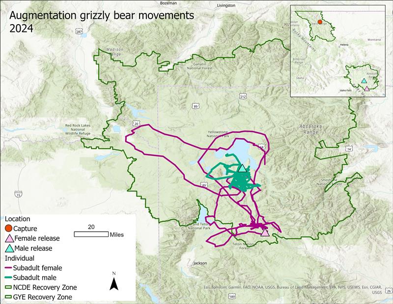 The bears were captured and collared within a day of each other southwest of east Glacier in a remote area of the Middle Fork of the Flathead River drainage in July and driven overnight to the GYE. One was a 3- to 4-year-old female; the other was a 4- to 5-year- old male.
“We were looking for the ideal bears,” McDonald said. “It’s actually not that easy to capture two bears that are prime candidates for translocation.”
In this case, the ideal bears were subadult, meaning they were older than cubs but not at sexual maturity yet, had no history of conflict and weighed enough to prepare for hibernation, McDonald said. Bears of this age are often in search of their permanent home range, therefore they are more likely to stay in the relocation than more mature individuals.
FWP worked with partners from the National Park Service and the Wyoming Game & Fish Department on the translocation destinations. The male bear was hauled by boat to the southern end of Yellowstone Lake. The female was taken to a remote location in the Blackrock Creek drainage west of Dubois, Wyo.
“We are very pleased to see that both bears have remained in the GYE, even staying mostly within remote areas of the Recovery Zone,” said Cecily Costello, FWP grizzly bear researcher. “It’s not always easy for a bear to adjust after being moved like this, but they seem to be settling in. We believe both have recently found a den site for the winter.”
Population recovery levels in the NCDE and GYE were passed several years ago. Montana has petitioned the U.S. Fish and Wildlife Service to delist bears in the NCDE, and Wyoming, with support from Montana and Idaho, has petitioned to delist grizzly bears in the GYE.
In both ecosystems, the states have met the delisting requirements and addressed concerns identified by the public or lined out by federal courts that have overturned previous delisting efforts. Those elements include:
* Reaching population recovery
* Having conflict prevention and response programs in place
* Continuing with research and monitoring
* Establishing a regulatory framework for managing grizzly bears once delisted
* Continuing with education and outreach about grizzly bears
* Safeguarding genetic health
According to McDonald, Montana and Wyoming have and will continue to act on their commitment to connectivity, and the agencies will continue to monitor the bears and their genetics to check for population diversity.
“That these bears are exploring their new ecosystem and seem to be doing well is an indication that they’ll thrive in their new environment,” McDonald said. “It also reflects the commitment Montana has to grizzly bear conservation.”
The lines show the movements of the female grizzly bear (pink) and male grizzly bear (green) that were relocated from the Northern Continental Divide Ecosystem (NCDE) to the Greater Yellowstone Ecosystem (GYE) this past summer. Both ecosystems have populations of grizzly bears that have surpassed recovery goals. However, the translocation effort was designed to help increase the genetic diversity of the GYE population, which has been isolated from nearby populations for many years. It’s an effort that may be repeated in the future, depending on how close the two populations eventually grow.
“This just jump starts what very likely will also happen naturally,” said Ken McDonald, head of Montana Fish, Wildlife & Parks’ Wildlife Division.
“We were looking for the ideal bears,” McDonald said. “It’s actually not that easy to capture two bears that are prime candidates for translocation.”
In this case, the ideal bears were subadult, meaning they were older than cubs but not at sexual maturity yet, had no history of conflict and weighed enough to prepare for hibernation, McDonald said. Bears of this age are often in search of their permanent home range, therefore they are more likely to stay in the relocation than more mature individuals.
FWP worked with partners from the National Park Service and the Wyoming Game & Fish Department on the translocation destinations. The male bear was hauled by boat to the southern end of Yellowstone Lake. The female was taken to a remote location in the Blackrock Creek drainage west of Dubois, Wyo.
“We are very pleased to see that both bears have remained in the GYE, even staying mostly within remote areas of the Recovery Zone,” said Cecily Costello, FWP grizzly bear researcher. “It’s not always easy for a bear to adjust after being moved like this, but they seem to be settling in. We believe both have recently found a den site for the winter.”
Population recovery levels in the NCDE and GYE were passed several years ago. Montana has petitioned the U.S. Fish and Wildlife Service to delist bears in the NCDE, and Wyoming, with support from Montana and Idaho, has petitioned to delist grizzly bears in the GYE.
In both ecosystems, the states have met the delisting requirements and addressed concerns identified by the public or lined out by federal courts that have overturned previous delisting efforts. Those elements include:
* Reaching population recovery
* Having conflict prevention and response programs in place
* Continuing with research and monitoring
* Establishing a regulatory framework for managing grizzly bears once delisted
* Continuing with education and outreach about grizzly bears
* Safeguarding genetic health
According to McDonald, Montana and Wyoming have and will continue to act on their commitment to connectivity, and the agencies will continue to monitor the bears and their genetics to check for population diversity.
“That these bears are exploring their new ecosystem and seem to be doing well is an indication that they’ll thrive in their new environment,” McDonald said. “It also reflects the commitment Montana has to grizzly bear conservation.”
Wednesday, December 18, 2024
Winter recreation begins Friday on Grand Teton National Park roads
Teton Park Road, Moose-Wilson Road, and Signal Mountain Summit Road will be open to winter recreation starting Friday, December 20. Enjoy cross-country skiing, snowshoeing and walking in the park during this special time of year.
Teton Park Road will be groomed between Taggart Lake parking and Signal Mountain Lodge, Friday, December 20 through mid-March as conditions allow. The road will be groomed three times a week on Tuesdays, Fridays, and Sundays, weather permitting. Three lanes will be groomed north of Cottonwood Creek Pullout for about one mile. Beyond that, it will change to two lanes.
Parking is available at Taggart Lake Trailhead, Cottonwood Creek Picnic Area and at the gate at the north end of the Teton Park Road near Signal Mountain Lodge.
Grooming is made possible through financial support from Grand Teton National Park Foundation and a Federal Highway Administration Recreational Trails Program Grant managed by the State of Wyoming.
Wheeled vehicles, including fat tire and electric bikes, are not allowed on roads designated for winter recreation activities. Bikes are only allowed on roadways open to motor vehicles.
Dogs are welcome to recreate alongside their owners on the Teton Park Road. For the safety of wildlife, visitors and their pets, dogs must always be leashed, are not allowed in the backcountry and must be picked up after. Dog sledding and skijoring are prohibited within Grand Teton National Park and the John D. Rockefeller, Jr. Memorial Parkway.
Additional Winter Recreation Activities and Information:
* Snowshoe with a Ranger programs are offered Tuesdays and Fridays from January 7 to March 14, 2025. Call 307-739-3399 to make a reservation.
* Backcountry camping permits are available 24 hours in advance. Call the park’s permit office at 307-739-3309 Monday through Friday. On weekends, call Teton Interagency Dispatch Center at 307-739-3301.
* Winter activities at Colter Bay include primitive camping, cross-country skiing, snowshoeing and ice fishing on Jackson Lake. Primitive winter camping is allowed in the Colter Bay Visitor Center parking lot from December 1 through April 15, with a $5 per night fee, which can be paid at the Moran Entrance Station.
* Always check the avalanche forecast from Bridger-Teton Avalanche Center before heading into the backcountry. Use careful snowpack assessment and good terrain choices to keep yourself safe.
* Be a steward for bighorn sheep and other wildlife who survive brutal winter conditions in the Tetons. Stress from human disturbances like skiing and snowboarding can push these iconic animals towards starvation. Protect wildlife by observing closures, avoiding bighorn sheep winter zones and giving all wildlife plenty of space (100 yards from bears and wolves and 25 yards from all other wildlife.)
* Limited services and seasonal closures make a Winter in Grand Teton visit very different from a summer experience. Before coming to the park, plan ahead, check conditions, be flexible, and pack food, water and extra layers of clothing.
Tuesday, December 17, 2024
Hiking books make great last-minute gifts!
Christmas is just a week away! Still trying to figure out what to give to your hiking friends and relatives? Why not give the gift of a hikers dream bucket list? Our books (see below) provide all the information hikers will need to discover new hiking adventures throughout Glacier, Grand Teton, and across the entire Rocky Mountain Range.
Right now my entire collection of eBooks are half off at Amazon – just $4.95 each! They'll soon be returning to full price....
**********************************************************************************
From Montana to New Mexico, the American Rockies stretch for more than a thousand miles. Within this spectacular mountain range are thousands of miles of hiking trails. With such an overwhelming number of options, how will you find and choose the most scenic and rewarding hikes?
Ultimate Hiking Guide to the Rocky Mountains takes all the guesswork out by focusing on some of the most amazing hikes across this range, and provides you with a handpicked list of options that will allow you to make the most of your trips in the Rockies:
[This book is also available in paperback]
**********************************************************************************
Glacier National Park preserves more than a million acres of some of the most spectacular scenery on Earth. With more than 740 miles of trails meandering throughout this vast park, how will you find and choose the most scenic and rewarding hikes?
Exploring Glacier National Park takes all the guesswork out by focusing on the most amazing hikes, and provides you with handpicked recommendations that will allow you to make the most of your trip to Glacier:
**********************************************************************************
Rising more than 7000 feet above Jackson Hole, the majestic mountains of Grand Teton National Park provide one of the most dramatic landscapes in the world. With more than 240 miles of trails meandering throughout this park, how will you find and choose the most scenic and rewarding hikes?
Exploring Grand Teton National Park takes all the guesswork out by focusing on the most amazing hikes, and provides you with handpicked recommendations that will allow you to make the most of your trip to Grand Teton:
**********************************************************************************
Virtually no one went hiking before the 19th century. What occurred that inspired ordinary people to take a walk in the woods for pleasure?
Ramble On explores the rich history of hiking, and how it evolved into one of the most popular pastimes in the world:
[This book is also available in paperback]
As always, thank you very much!
Thursday, December 12, 2024
Five Great Reasons to Visit Rocky Mountain National Park
Encompassing more than 265,000 acres, and with more than sixty peaks topping out above 12,000 feet, Rocky Mountain National Park is home to some of the most spectacular scenery on Earth. From wooded forests to alpine tundra, these majestic mountains provide habitat to more than 60 species of mammals, while more than 280 species of birds visit or reside within the park. With more than 350 miles of trails meandering throughout the park, Rocky Mountain is also widely recognized as a hiker’s paradise. Here are five great reasons why you should visit Rocky Mountain:
The Continental Divide
One of the best things about Rocky Mountain National Park is its accessibility to the high country. No other park in the country allows visitors to gain lofty elevations so easily. Roughly one-third of the park is above tree-line, and more than 60 peaks top out above 12,000 feet, including 14,259-foot Longs Peak, the highest peak in the park. In addition to trails like the Flattop Mountain Trail or the route to Mt. Ida, visitors can drive over the Continental Divide along the highest continuous paved road in North America. With a maximum elevation of 12,183 feet, and more than eight miles traveling above 11,000 feet, Trail Ridge Road connects Estes Park with Grand Lake. The road also provides access to several outstanding tundra hikes, such as the Ute Trail, the Tundra Communities Trail and the Alpine Ridge Trail. Each of these are categorized as easy or moderate hikes, but don't forget to acclimate first!

Wildflowers
Wet springs can bring exceptional wildflower seasons to Rocky Mountain National Park. Even during normal years the park explodes with a variety of wildflowers. Some of the varieties visitors might enjoy include Alpine Clover, Rock Primrose, Western Wallflower, Sky Pilot and Alpine Sunflowers in the tundra areas of the park, as well as Mountain Iris, Lupine, Mariposa-lily and Colorado Columbines in the lower elevations. Some of best wildflower hikes include Big Meadows, Cascade Falls, Emerald Lake and the Lumpy Ridge Loop, among many others.

Longs Peak
At 14,259 feet, Longs Peak is the highest mountain in Rocky Mountain National Park. The iconic sentinel is seen from almost anywhere in the park, as well as from many locations around northern Colorado. It’s also one of most popular “fourteeners” for hikers and climbers to tackle in a state that boasts 53 peaks that rise above 14,000 feet. Although considered a mountaineering route, thousands of hikers attempt to summit the peak each summer using the famous Keyhole Route. Personally, I don’t want anything to do with the narrow ledges and steep cliffs along the upper portions of the route. I much prefer safer climbs such as Hallett Peak and the Chapin-Chiquita-Ypsilon Mountains to cure my big mountain summit fever.

Elk Rut
The annual elk rut is one of the premier attractions in Rocky Mountain National Park. Each fall elk descend from the high country to the lower elevation meadows during the annual breeding season. During the rut, bull elk compete with one another for the right to breed with herds of females. Mature bulls compete for cows by bugling, posturing, displaying their antlers and herding, while occasionally fighting off young challengers. The peak season for the rut generally lasts from mid-September to mid-October in Rocky Mountain National Park.

Fall Aspens
Just as the elk rut is kicking into high gear, another annual event that draws tourists to the park during the autumn are the brilliant fall colors of aspens. Each September the leaves of quacking aspens turn from green to orange and golden yellow throughout the park. Some of best hikes for viewing fall aspens include Bierstadt Lake, Alberta Falls, Cub Lake, Finch Lake, Adams Falls and Chasm Lake, among many others.

In addition to the hikes discussed above, Rocky Mountain National Park has many other outstanding hikes that take-in the best scenery the park has to offer. If you do plan to visit Rocky Mountain this year, please note that our hiking website also offers a wide variety of accommodation listings and other things to do to help with all your vacation planning.
*******************************************************************************
From Montana to New Mexico, the American Rockies stretch for more than a thousand miles. Within this spectacular mountain range are thousands of miles of hiking trails. With such an overwhelming number of options, how will you find and choose the most scenic and rewarding hikes?
Ultimate Hiking Guide to the Rocky Mountains takes all the guesswork out by focusing on some of the most amazing hikes across this range, and provides you with a handpicked list of options that will allow you to make the most of your trips in the Rockies:
The Continental Divide
One of the best things about Rocky Mountain National Park is its accessibility to the high country. No other park in the country allows visitors to gain lofty elevations so easily. Roughly one-third of the park is above tree-line, and more than 60 peaks top out above 12,000 feet, including 14,259-foot Longs Peak, the highest peak in the park. In addition to trails like the Flattop Mountain Trail or the route to Mt. Ida, visitors can drive over the Continental Divide along the highest continuous paved road in North America. With a maximum elevation of 12,183 feet, and more than eight miles traveling above 11,000 feet, Trail Ridge Road connects Estes Park with Grand Lake. The road also provides access to several outstanding tundra hikes, such as the Ute Trail, the Tundra Communities Trail and the Alpine Ridge Trail. Each of these are categorized as easy or moderate hikes, but don't forget to acclimate first!
Wildflowers
Wet springs can bring exceptional wildflower seasons to Rocky Mountain National Park. Even during normal years the park explodes with a variety of wildflowers. Some of the varieties visitors might enjoy include Alpine Clover, Rock Primrose, Western Wallflower, Sky Pilot and Alpine Sunflowers in the tundra areas of the park, as well as Mountain Iris, Lupine, Mariposa-lily and Colorado Columbines in the lower elevations. Some of best wildflower hikes include Big Meadows, Cascade Falls, Emerald Lake and the Lumpy Ridge Loop, among many others.
Longs Peak
At 14,259 feet, Longs Peak is the highest mountain in Rocky Mountain National Park. The iconic sentinel is seen from almost anywhere in the park, as well as from many locations around northern Colorado. It’s also one of most popular “fourteeners” for hikers and climbers to tackle in a state that boasts 53 peaks that rise above 14,000 feet. Although considered a mountaineering route, thousands of hikers attempt to summit the peak each summer using the famous Keyhole Route. Personally, I don’t want anything to do with the narrow ledges and steep cliffs along the upper portions of the route. I much prefer safer climbs such as Hallett Peak and the Chapin-Chiquita-Ypsilon Mountains to cure my big mountain summit fever.
Elk Rut
The annual elk rut is one of the premier attractions in Rocky Mountain National Park. Each fall elk descend from the high country to the lower elevation meadows during the annual breeding season. During the rut, bull elk compete with one another for the right to breed with herds of females. Mature bulls compete for cows by bugling, posturing, displaying their antlers and herding, while occasionally fighting off young challengers. The peak season for the rut generally lasts from mid-September to mid-October in Rocky Mountain National Park.
Fall Aspens
Just as the elk rut is kicking into high gear, another annual event that draws tourists to the park during the autumn are the brilliant fall colors of aspens. Each September the leaves of quacking aspens turn from green to orange and golden yellow throughout the park. Some of best hikes for viewing fall aspens include Bierstadt Lake, Alberta Falls, Cub Lake, Finch Lake, Adams Falls and Chasm Lake, among many others.
In addition to the hikes discussed above, Rocky Mountain National Park has many other outstanding hikes that take-in the best scenery the park has to offer. If you do plan to visit Rocky Mountain this year, please note that our hiking website also offers a wide variety of accommodation listings and other things to do to help with all your vacation planning.
*******************************************************************************
From Montana to New Mexico, the American Rockies stretch for more than a thousand miles. Within this spectacular mountain range are thousands of miles of hiking trails. With such an overwhelming number of options, how will you find and choose the most scenic and rewarding hikes?
Ultimate Hiking Guide to the Rocky Mountains takes all the guesswork out by focusing on some of the most amazing hikes across this range, and provides you with a handpicked list of options that will allow you to make the most of your trips in the Rockies:
Tuesday, December 10, 2024
Yellowstone National Park's winter season begins Dec. 15, 2024
Yellowstone National Park’s winter season begins Sunday, Dec. 15. Annually from mid-December until mid-March, visitors can travel most of the park’s roads from the West, South, East and North entrances by approved commercially guided snowmobiles and snowcoaches and via the non-commercially guided snowmobile access program.
Currently, the accumulation of snowfall on roads varies across the park. This means that visitors will be able to travel in the park, however, the type of transportation used on park roads by commercially guided snowmobile or snowcoach tour companies will depend on road conditions. Throughout the winter season, park staff will work closely with all operators and provide updates as conditions change.
Winter travel ends in mid-March when plowing crews begin to clear a winter’s worth of snow. Roads will start to re-open to automobiles beginning in mid-April.
Most facilities are closed during winter. Check winter operating dates to see which visitor centers, stores, restaurants, lodges and warming huts are open. You can download the free National Park Service App (and offline content) before you arrive.
Sunday, December 8, 2024
NPS announces 2025 free entrance days
Are you ready to explore the breathtaking beauty of America's national parks? In 2025, the National Park Service (NPS) invites everyone, especially those who may not have considered a visit, to plan and prepare for their next national park trip early. Next year, the National Park Service will waive the entrance fee to national parks on six days —an opportunity to experience the wonders of nature, culture, and history without the cost of entry!
On designated days throughout the year, all visitors can enjoy free entrance to more than 400 national parks across the country. Whether you are a family looking for a weekend getaway, friends seeking a memorable outing, or even solo adventurers desiring to connect with nature, free entrance days make it easier for everyone to explore the parks.
The 2025 free entrance days are:
January 20 – Martin Luther King, Jr. Day
April 19 – First Day of National Park Week
June 19 – Juneteenth National Independence Day
August 4 – Great American Outdoors Act Signing Day
September 27 – National Public Lands Day
November 11 – Veterans Day
With over 400 national parks, monuments, and historic sites, there’s something for everyone. Visit NPS.gov/findapark to explore the park options nearest you.
Thursday, December 5, 2024
Five Great Reasons to Visit Grand Teton National Park
Rising more than 7000 feet above Jackson Hole, the lofty peaks of Grand Teton National Park provide one of the most dramatic landscapes in the entire world. Although many people seem to treat it as an afterthought, only visiting the park as a side trip while visiting its more famous neighbor to the north, more time and focus should be given to this stunning landscape. Within its 310,000 acres the majestic mountains of the Teton Range are home to a wide variety of wildlife, eight peaks that top out above 12,000 feet, more than 100 alpine and backcountry lakes, and more than 240 miles of trails that provide intimate access to all of this incredibly beautiful scenery. The following are among some of the top reasons why you should pay a visit to this amazing park:
1) Cascade Canyon
The Cascade Canyon Trail is widely touted as one of the best hikes in the entire National Park System. In addition to the stunning views of 12,928-foot Mt. Owen, the trail visits Hidden Falls and Inspiration Point. The route is also known for the wide variety of wildlife that's frequently seen, especially bears and moose.

2) Lake Views
Lying along the eastern base of the Teton Range is a series of glacially-carved lakes. Rising sharply above their western shores, the views of the rugged mountains are stunning and dramatic. From the shores of Jackson, Leigh, Jenny, Phelps, Bradley and Taggart Lakes, hikers will enjoy some of the most striking views in the park, especially in the early morning.

3) Wildlife
Although Yellowstone rightfully receives a lot of attention for its wildlife viewing opportunities, the Grand Tetons are also known for its diversity of wildlife. The rugged mountains provide habitat to a wide variety of wildlife, including black bears, grizzly bears, elk, bison, bighorn sheep, moose, pronghorn, wolves, fox, lynx, bobcats and mountain lions. There are also more than 300 species of birds, including trumpeter swans, ospreys and bald eagles. A drive along Moose-Wilson Road is a popular way of spotting mega fauna, such as bears and moose. However, hikes such as Amphitheater Lake, Hermitage Point, Moose Ponds and the Emma Matilda Lake Loop are all great choices if you're wishing to spot wildlife in the backcountry.

4) Photography
The abrupt rise of the Tetons from the valley floor arguably makes them one of the most photogenic mountain ranges in the world. As a result, professional and amateur photographers alike will enjoy a multitude of photo opportunities around the park. Some of the best spots for getting that perfect shot include Mormon Row, Oxbow Bend, Schwabacher’s Landing, as well as the Snake River Overlook, which was made famous by Ansel Adams' 1942 photograph. Of course all of the backcountry locations mentioned above will also provide outstanding photo opportunities.

5) Snake River Float Trip
The Snake River meanders along the sage brush flats below the Teton Range, and provides park visitors with the unique opportunity of enjoying the majestic mountain scenery from a raft. Although outfitters offer trips throughout the day, I highly recommend the morning trips, as the mountains typically look their finest when bathed in the glow of early morning sunshine. Morning also provides the best opportunity for spotting wildlife along the river banks, including bald eagles.

With more than 240 miles of trails meandering throughout the park, hiking is the absolute best way to see Grand Teton National Park. In addition to the hikes listed above, the park offers a variety of other outstanding hikes. If you do plan to visit Grand Teton this year, please note that our hiking website also offers a wide variety of accommodation listings as well as other things to do to help with all your vacation planning.
*******************************************************************************
Rising more than 7000 feet above Jackson Hole, the majestic mountains of Grand Teton National Park provide one of the most dramatic landscapes in the world. With more than 240 miles of trails meandering throughout this park, how will you find and choose the most scenic and rewarding hikes?
Exploring Grand Teton National Park takes all the guesswork out by focusing on the most amazing hikes, and provides you with handpicked recommendations that will allow you to make the most of your trip to Grand Teton:
1) Cascade Canyon
The Cascade Canyon Trail is widely touted as one of the best hikes in the entire National Park System. In addition to the stunning views of 12,928-foot Mt. Owen, the trail visits Hidden Falls and Inspiration Point. The route is also known for the wide variety of wildlife that's frequently seen, especially bears and moose.
2) Lake Views
Lying along the eastern base of the Teton Range is a series of glacially-carved lakes. Rising sharply above their western shores, the views of the rugged mountains are stunning and dramatic. From the shores of Jackson, Leigh, Jenny, Phelps, Bradley and Taggart Lakes, hikers will enjoy some of the most striking views in the park, especially in the early morning.
3) Wildlife
Although Yellowstone rightfully receives a lot of attention for its wildlife viewing opportunities, the Grand Tetons are also known for its diversity of wildlife. The rugged mountains provide habitat to a wide variety of wildlife, including black bears, grizzly bears, elk, bison, bighorn sheep, moose, pronghorn, wolves, fox, lynx, bobcats and mountain lions. There are also more than 300 species of birds, including trumpeter swans, ospreys and bald eagles. A drive along Moose-Wilson Road is a popular way of spotting mega fauna, such as bears and moose. However, hikes such as Amphitheater Lake, Hermitage Point, Moose Ponds and the Emma Matilda Lake Loop are all great choices if you're wishing to spot wildlife in the backcountry.

4) Photography
The abrupt rise of the Tetons from the valley floor arguably makes them one of the most photogenic mountain ranges in the world. As a result, professional and amateur photographers alike will enjoy a multitude of photo opportunities around the park. Some of the best spots for getting that perfect shot include Mormon Row, Oxbow Bend, Schwabacher’s Landing, as well as the Snake River Overlook, which was made famous by Ansel Adams' 1942 photograph. Of course all of the backcountry locations mentioned above will also provide outstanding photo opportunities.
5) Snake River Float Trip
The Snake River meanders along the sage brush flats below the Teton Range, and provides park visitors with the unique opportunity of enjoying the majestic mountain scenery from a raft. Although outfitters offer trips throughout the day, I highly recommend the morning trips, as the mountains typically look their finest when bathed in the glow of early morning sunshine. Morning also provides the best opportunity for spotting wildlife along the river banks, including bald eagles.
With more than 240 miles of trails meandering throughout the park, hiking is the absolute best way to see Grand Teton National Park. In addition to the hikes listed above, the park offers a variety of other outstanding hikes. If you do plan to visit Grand Teton this year, please note that our hiking website also offers a wide variety of accommodation listings as well as other things to do to help with all your vacation planning.
*******************************************************************************
Rising more than 7000 feet above Jackson Hole, the majestic mountains of Grand Teton National Park provide one of the most dramatic landscapes in the world. With more than 240 miles of trails meandering throughout this park, how will you find and choose the most scenic and rewarding hikes?
Exploring Grand Teton National Park takes all the guesswork out by focusing on the most amazing hikes, and provides you with handpicked recommendations that will allow you to make the most of your trip to Grand Teton:
Wednesday, December 4, 2024
Flathead Avalanche Center begins daily forecasts
Starting this week, through early April (depending on snow conditions), the Flathead Avalanche Center will provide daily forecasts of avalanche conditions seven days a week. Forecasts with avalanche danger ratings and snowpack observations can be found usually by 7:00 a.m. on the Flathead Avalanche Center website: http://www.flatheadavalanche.org/
Avalanche danger varies daily, so it is advised to check forecasts regularly. Flathead Avalanche Center also offers avalanche condition updates through email subscription. To sign up, visit: https://flatheadavalanche.org/newsletter/
Awareness of avalanche hazards is critical for anyone planning mountain travel in the winter. These forecasts provide current conditions, based on real-time observations of the snowpack for the Whitefish Range, Swan Range, Flathead Range and Glacier National Park. Daily forecasts provide information on conditions and areas that may be most dangerous for that day, and what terrain offers the lowest risk. Forecasts include an overview and broad travel advice for three elevation bands, as well as more detailed avalanche information needed for specific trip planning decisions.
Field observations from the public are highly valuable to forecasters as they analyze conditions; the Flathead Avalanche Center encourages you to submit observations through their easy to use digital form: https://www.flatheadavalanche.org/observations/submit-observations/#/advanced-form
Adult avalanche courses are available through the Friends of the Flathead Avalanche Center (FOFAC), providing education on essential avalanche skills and knowledge for a variety of skill levels. To register, visit Flathead Avalanche Center Education website at: https://flatheadavalanche.org/education/avalanche-courses/
Flathead Avalanche Center is a service provided by the Flathead National Forest, and is funded by the Flathead National Forest, Glacier National Park, the state of Montana, and donations to Friends of the Flathead Avalanche Center. The Type 1 Center staffs four full-time forecast and observer staff and provides daily avalanche forecasts for three geographic regions: the Swan Range, the Whitefish Range, and the Flathead Range and Glacier National Park.
Sunday, December 1, 2024
Missing Hiker Found Alive After Surviving 50 Days in Canadian Wilderness
On Tuesday, November 26, at 11:30 am, Northern Rockies RCMP were notified that Sam Benastick, who was reported missing on October 19, 2024 had been located.
Two people were headed to the Redfern Lake trail for work, where they saw a man walking toward them. When they approached the man, they recognized him as Sam Benastick.
The two men took Sam to the hospital where police attended and confirmed the man to be the man reported missing.
Benastick told police that he stayed in his car for a couple of days and then walked to a creek, mountain side where he camped out for 10-15 days. Then moved down the valley, and built a camp and shelter in a dried-out creek bed. He then made his way to the location where he flagged down the two men and was taken to safety.
The CBC reported that Benastick was suffering from "frostbite and some smoke inhalation." A SAR volunteer from Prince George described the situation as being "incredibly challenging winter conditions." The area received more than 6 inches of snow, and temperatures had dipped below -4 degrees Fahrenheit.
Finding Sam alive is the absolute best outcome. After all the time he was missing, it was feared that this was would not be the outcome said Cpl Madonna Saunderson, BC RCMP Communications.
The RCMP thanked the Fort Nelson and North Peace and Search and Rescue teams including other Search and Rescue jurisdictions that provided mutual aid support, the Canadian Rangers along with many local volunteers with extensive back country knowledge of the area.
There are a few more details about the story in this CBC News report, though it's obvious many are still to be told:
*******************************************************************************
From Montana to New Mexico, the American Rockies stretch for more than a thousand miles. Within this spectacular mountain range are thousands of miles of hiking trails. With such an overwhelming number of options, how will you find and choose the most scenic and rewarding hikes?
Ultimate Hiking Guide to the Rocky Mountains takes all the guesswork out by focusing on some of the most amazing hikes across this range, and provides you with a handpicked list of options that will allow you to make the most of your trips in the Rockies:
Friday, November 29, 2024
Daines' bill seeks reauthorization of fund to address NPS maintenance backlog
U.S. Senators Steve Daines and Angus King (I-Maine), along with Senators Kevin Cramer (R-N.D.) and Mark Warner (D-Va.), have recently introduced the “America the Beautiful Act.” The bill would reauthorize the National Parks and Public Land Legacy Restoration Fund (LRF) and increase funding for public land management.
“People travel from every corner of the world to connect with America’s incredible natural beauty and to make memories that last a lifetime,” said King. “However, deferred repairs on aging infrastructure like roads and trails can become unsafe for visitors and diminish the quality of our public lands and National Parks. The bipartisan America the Beautiful Act protects our lands and the visitor experience — by addressing maintenance backlogs and reauthorizing the historic Legacy Restoration Fund. This legislation is an important step forward in establishing lasting protections for our public lands, and serves as a proud reminder that stewardship is not a partisan issue.”
“The Great American Outdoors Act brought real results to North Dakota’s outdoor recreation opportunities,” said Cramer. “Visitors to Theodore Roosevelt National Park will be able to travel the South Loop road, which washed out several years ago, and recreationists can enjoy the updated trails and campsites in the nearby grasslands. Let’s keep this momentum going by passing the America the Beautiful Act, so we maintain our national treasures.”
Background:
Senator Daines introduced the “The Great American Outdoors Act,” in the 116th Congress which was signed into law by President Trump in 2020 and authorized the LRF for five years to address the maintenance backlog on public lands and national parks. The “America the Beautiful Act” reauthorizes and strengthens the LRF for 8 years (through 2033) and also does the following:
* Increases funding from $1.9 billion to $2 billion per year
* Prioritizes projects that have a 15 percent match from stakeholders
* Requires agencies to have a two-year running list of projects
* Allows the agencies to move forward with next year’s projects under a Continuing Resolution
* Ensures that all lands administered by the Fish and Wildlife Service are eligible
* Bolsters the ability for public donations to the fund by requiring agencies to run public awareness campaigns and make known the ability to donate
* Requires the agencies to assess and dispose of unneeded constructed assets
* Requires additional reporting to Congress on actions taken by the agency to reduce their Deferred Maintenance backlogs.
* Read the text of the bill HERE.
The National Park Foundation, National Parks Conservation Association (NPCA), Montana Outfitters and Guides Association, Friends of Acadia, Boone and Crockett, and the Congressional Sportsmen’s Foundation are among many groups supporting the legislation.
Monday, November 25, 2024
How to help the victims of Hurricane Helene during Christmas
Before jumping into the main point of my post, I'm writing this because it feels like the media has forgotten the victims of Hurricane Helene, especially those who live in North Carolina. The situation on the ground is far worse than you probably think. I don't know the numbers, but there are still many people living in tents, and winter is already moving into the mountains. If you're not aware of how bad things are, I would encourage you to do a little snooping on social media, and listen to the testimony of those who have been impacted.
Last week I ran into a Twitter post that provided a great idea for helping the victims of Hurricane Helene during the upcoming Christmas season. That is; by doing as much of your online Christmas shopping as possible by purchasing from small businesses in hurricane-ravaged areas. This post picks-up on that theme by focusing on businesses in areas that felt the greatest impact during the late-September storm, namely Western North Carolina. In particular, I focused on businesses that I thought hikers and outdoor enthusiasts would be most interested in. I also provided links to lists of currently open businesses so that you can find gifts from a broader universe of stores. Many of these businesses have sustained damage or have completely lost their physical store fronts, but were able to maintain their online stores. Businesses that managed to escape damage have also been greatly impacted, as tourism to the region has been shaprly curtailed. As a result, many of these business owners are in dire straight right now. All of them, I asure you, would greatly appreciate your business!
In addition to the links below, you should note that many lodging, attractions, wineries and restaurants are currently open. They desperately could use your business as well. Not just for the owners, but their employees as well. Moreover, any money spent at any business in the area helps to circulate much needed cash thoughout the community.
The Twitter posts that I saw are using these hashtags to get the word out, if you wish to help in that way: #ShopWNC / #ShopAsheville / #ShopHurricaneHelene
Each of the local businesses listed below I believe are open for online shopping:
Hiking, outdoor gear shops and local manufacturers
Mast General Store is a local institution originally out of Asheville: https://www.mastgeneralstore.com/
Regear Outdoors: https://regearnc.com/
Though the store was closed as of 10/18, Headwaters Outfitters stated in a newspaper article "In the meantime, you can shop the outdoor shop’s online store (send a note saying “Ship when the time is right”, Headwater recommends) or purchase a gift card for a future trip." https://shopheadwatersoutdoors.com/
Diamond Brand Gear: https://www.diamondbrandgear.com/
Eagles Nest Outfitters: https://eaglesnestoutfittersinc.com/
Astral Designs: https://astraldesigns.com/
This is Jen Pharr Davis's business - a legendary hiker. She has an online store, but she's also currently offering guided hikes: https://blueridgehikingco.com/
This Marshall, NC bike shop was completely devastated, but they're still selling a few cycling related items: https://www.oyb-nc.com/merch
Goodies and Gifts
What hikers don't like a little something sweet after a long hike? Many offerings here, all would also make great gift items:
French Broad Chocolate: https://www.frenchbroadchocolates.com/
The Chocolate Fetish: https://www.chocolatefetish.com/
The Dillsboro Chocolate Factory: https://www.dillsborochocolate.com/
Cold Mountain Toffee: https://www.coldmountaintoffee.com/
Ashe County Cheese: https://www.ashecountycheese.com/
Poppy Handcrafted Popcorn: https://poppyhandcraftedpopcorn.com/
Breweries
And seriously, what hikers don't like beer?!? If you're in their distribution region, check out the beers from these WNC breweries next time you're in a grocery store, liquor store, bar or restaurant. You can also support them by purchasing merchandise and gift cards from their online stores. There are dozens of breweries in the impacted region, many completely wiped out, however, these were the few that I could confirm that have regional distribution of their beers. There are likely many more, especially for those who live in North Carolina:
Highland Brewing is one of the finest craft breweries around, IMHO. Normally, I'm not a fan of winter ales or spiced beers, but their Cold Mountain is outstanding if you're looking for something for the holiday spirit! https://highlandbrewing.com/hurricane-helene-response/
Catawba Brewing Company: https://www.catawbabrewing.com/
Hi-Wire Brewing: https://hiwirebrewing.com/
Appalachian Mountain Brewing: https://www.amb.beer/
Weekend Getaways
Southern Living published an article last week that lays out 13 towns in the hurricane's path that are currently welcoming guests. The article includes information on things to do in each area.
Yes!! There are still a lot of trails open in WNC. All of the trails on the TN side of the Great Smoky Mountains are open as well.
The Nantahala Outdoor Center is currently offering fully guided trips, rentals, zip lines, and aerials. Their Outfitter’s Store, Lodging, and the Rivers End Restaurant are open for business as well. https://noc.com/noc-operations-updates/
The world-famous Biltmore in Asheville has also reopened: https://www.biltmore.com/things-to-do/events/christmas/
Tuckaseegee Fly Shop: https://www.tuckflyshop.com/
There are many other businesses open in the area. You can check on the following websites in some of the hardest hit areas to see what's open. Any and all of them would greatly appreciate your business!
General info:
https://www.exploreasheville.com/article/heres-what-reopened-asheville-buncombe-county-post-hurricane-helene
https://www.charlotteobserver.com/charlottefive/c5-around-town/c5-development/article293591474.html
Marshall & Hot Springs:
https://madisoncounty-nc.com/business-directory/
https://www.shopwnc.com/business-listings/hot-springs
https://www.shopwnc.com/business-listings/marshall
Swannanoa, Maggie Valley and Waynesville:
https://www.shopwnc.com/business-listings/maggie-valley
https://www.shopwnc.com/business-listings/waynesville
https://visithaywood.com/blog/haywood-county-business-updates-closures-post-hurricane-helene/
Chimney Rock & Lake Lure:
https://www.shopwnc.com/business-listings/lake-lure
Erwin, TN:
https://realwildunicoicounty.com/downtown/
https://unicoicounty.org/directory/
Other ways to help:
Samaritan's Purse - is still on the ground and doing wonderful work: https://www.samaritanspurse.org/article/pray-for-those-in-helenes-path/
Checkout the "Together We Rise T-Shirt" Proceeds go towards supporting Hurricane Helene relief: https://fuelgoods.com/products/together-we-rise-t-shirt-supporting-hurricane-helene-relief
DeFeet's Aireator 6" MTN Strong cycling socks. Proceeds also go towards supporting Hurricane Helene relief: https://defeet.com/products/aireator-6-mtn-strong
There are many other organizations on the ground that are doing great work. Before donating, however, I would highly encourage you to do a little homework first to make sure that as much of your donation is going towards the mission as possible, and not feeding a bloated bureaucracy. Unfortunately, there are many "charities" out there who are paying enourmous salaries to their boards of directors and management teams.
************************************************************************************
Check out our online trail guides:
- Glacier National Park: HikinginGlacier.com
- Grand Teton National Park: TetonHikingTrails.com
- Rocky Mountain National Park: RockyMountainHikingTrails.com
Sunday, November 24, 2024
Grand Teton National Park on pace to see busiest year since 2021
Grand Teton National Park hosted more than 3.5 million recreation visits between January and October, already making 2024 the second busiest year on record. The busiest year on record is 2021, with almost 3.9 million recreation visits for the entire year. Four of the last ten months have been the second busiest months.
“Even though the year isn’t over yet, the data shows us that Grand Teton National Park continues to resonate with millions of visitors,” said Superintendent Chip Jenkins. “As visitation trends change, we will need to figure out how to respond to and manage those changes for the good of visitors, park resources, and our local communities.”
When and how people visit the park continues to change. Some of the largest increases in recreation visits occurred during the shoulder seasons, including April, May, and October. Arrivals increased at the Moose Entrance while wildfires affected U.S. Highway 26/287 east of the park. And more visitors hit the trails this summer than ever before. Trail use increased by about 16% compared to 10 years ago and by about 4% compared to five years ago.
In an effort to better understand changing visitation and how people use the park, we asked the public over the summer for their input about desired conditions and visitor experiences. Park staff are reviewing and analyzing the comments and will use that information to ensure visitors continue to have high-quality experiences in the park.
Visitation figures are a valuable tool used by the NPS to manage public enjoyment of Grand Teton National Park while monitoring resource conditions and the quality of the visitor experience. The NPS Stats website has more information about visitation statistics at Grand Teton and all national parks.
Thursday, November 21, 2024
Seven Great Reasons to Visit Glacier National Park
Fully realizing this may sound a little over-the-top, but every person living in this country should visit Glacier National Park at least once in their life. It will forever change them. John Muir once said of Glacier:
Unparalleled Beauty
In my humble opinion, Glacier National Park is by far the most beautiful park I’ve ever been to. This includes almost every major national park in the lower 48. As a disclaimer, I should note that I haven’t had a chance to explore the interior of Alaska….yet. Having said that, my love affair with this park began immediately the first time I laid eyes on it. To be precise, it was during the drive from Browning along Highway 2 as we approached the East Glacier/Two Medicine area. My love and awe for the park has grown after each subsequent visit. At every turn on any road or trail is one spectacular scene after another. In fact, there are no bad or boring hikes. Photographers could spend a lifetime here taking photos of scenes that normally show up in Backpacker Magazine or National Geographic. One of the most famous photo locations in the entire National Park System is at a spot known as Wild Goose Island Overlook. You may recognize the scene in theis photo:

Glaciers
Most people assume that Glacier received its name as a result of the 25 glaciers located within the park. However, the park was actually given its name due to the rugged mountains that were carved by massive glaciers during the most recent ice ages. Fortunately for hikers, a few of these can be reached by trail. Some of the most popular hikes for enjoying front row views of glaciers include Iceberg Lake and Grinnell Glacier.

The Highline Trail
The Highline Trail from Logan Pass is widely recognized as one of the best hikes in the park, if not the entire National Park System. At every step, and every turn, hikers will enjoy spectacular scenery as they traverse along the Continental Divide. The exceptionally beautiful views, the excellent opportunities for spotting wildlife, and the wildflowers all combine to make this a hike you'll remember the rest of your life. If you can make it past the narrow ledge section near the trailhead you’ll have the option of traveling to Haystack Pass, Granite Park Chalet, or making the one-way hike to “The Loop”. You'll also have the option of taking the steep spur trail up to Grinnell Glacier Overlook.

The Going-to-the-Sun Road
The famous Going-to-the-Sun Road is the only road to cross Glacier National Park from east to west. The epic route transports visitors through some of the most spectacular scenery the park has to offer. This engineering marvel spans more than 50 miles across the park's interior, takes passengers over the Continental Divide at Logan Pass, and treats visitors to some of the grandest sights in the Rocky Mountains. Along its course the road passes glacial lakes and cedar forests in the lower valleys, as well as windswept alpine meadows and sweeping mountain vistas atop the 6646-foot pass.
Several scenic viewpoints and pullouts along the way provide motorists with ample opportunities to stop for extended views and photographs. Once at Logan Pass be sure to visit Hidden Lake Overlook, a relatively easy hike that takes hikers across the Continental Divide just above the Logan Pass Visitor Center.
Some drivers (and passengers) might be a little intimidated by the Going-to-the-Sun Road. Portions of it hug the mountainside as it traverses over steep drop-offs and steers through tight curves. If this gives you any pause, you may want to consider letting the drivers of the iconic Red "jammer" Buses take you across the mountains.

Wildlife
Outside of Yellowstone, Glacier National Park is arguably the best park for spotting and viewing wildlife. Although wildlife are frequently spotted along the road, a venture into the wilderness is likely to bring better results. Trails such as Iceberg Lake, Ptarmigan Tunnel, Grinnell Glacier and Swiftcurrent Pass are excellent choices if you wish to see a grizzly or black bear. Bullhead Lake, the Swiftcurrent Nature Trail, Dawson Pass and Cobalt Lake are all great choices for spotting moose. For bighorn sheep, check out Grinnell Glacier, Dawson Pass or the Highline Trail. For the best opportunities to possibly spot a mountain goat, check out Hidden Lake Overlook, the Highline Trail or Piegan Pass.

History, Culture and Ambiance
The Glacier experience is unlike any other national park. This is due in large part to its living history. Park visitors can still enjoy the magnificent grand lodges, backcountry chalets and trails that were built by the Great Northern Railway shortly after the turn of the 20th century. You can also relax and take in the sights in one of the historic boats that still ply the waters of Glacier's lakes. Another tradition from Glacier's bygone era are its famous Red Busses, which have been used as transportation since 1914. Visitors can take a step back in time by touring the park in one of these vehicles, each of which were built between 1936 and 1939. For unparalleled ambiance, there's absolutely nothing better than sipping a huckleberry beer on the back porch of the Many Glacier Hotel and soaking-in the profound beauty of Swiftcurrent Lake and the mountains that surround it. In many respects, and with maybe a little imaginaton, visitors can still enjoy a similar experience park visitors had in the past.
Backcountry Chalets
2024 marked the 110th anniversary of the Sperry and Granite Park Chalets. Both backcountry chalets were built in 1914 during a period when the Great Northern Railway was promoting Glacier National Park under the "See America First" campaign. Today the two backcountry chalets offer hikers the opportunity to trek to an overnight backcountry destination without being bogged down with a bunch of camping gear.
Perched at an elevation of more than 6500 feet, the Sperry Chalet sits high atop a rock ledge that offers visitors commanding views of majestic mountain peaks, waterfalls, as well as Lake McDonald in the valley far below. The Granite Park Chalet rests just below Swiftcurrent Pass, along the edge of a sub-alpine meadow that offers commanding views of Heavens Peak and the McDonald Valley. Day hikers and overnight guests commonly reach this chalet by one of three trails: the Highline Trail, the Granite Park Trail or the Swiftcurrent Pass Trail out of Many Glacier. Day hikers may want to note that Sperry Chalet also sells hot lunches.

With more than 740 miles of trails meandering throughout the park, hiking is the absolute best way to see Glacier National Park. In addition to the hikes listed above, the park offers a variety of other outstanding hikes. If you do plan to visit Glacier this year, please note that our hiking website also offers a wide variety of accommodation listings as well as other things to do to help with all your vacation planning.
*******************************************************************************
Glacier National Park preserves more than a million acres of some of the most spectacular scenery on Earth. With more than 740 miles of trails meandering throughout this vast park, how will you find and choose the most scenic and rewarding hikes?
Exploring Glacier National Park takes all the guesswork out by focusing on the most amazing hikes, and provides you with handpicked recommendations that will allow you to make the most of your trip to Glacier:
"Give a month at least to this precious reserve. The time will not be taken from the sum of your life. Instead of shortening, it will indefinitely lengthen it and make you truly immortal. Nevermore will time seem short or long, and cares will never again fall heavily on you, but gently and kindly as gifts from heaven."I know I can’t, but I'm pretty sure there aren’t too many people that can sum-up the Glacier experience better than Muir. Here are just a few of the reasons why I think Glacier is so special:
Unparalleled Beauty
In my humble opinion, Glacier National Park is by far the most beautiful park I’ve ever been to. This includes almost every major national park in the lower 48. As a disclaimer, I should note that I haven’t had a chance to explore the interior of Alaska….yet. Having said that, my love affair with this park began immediately the first time I laid eyes on it. To be precise, it was during the drive from Browning along Highway 2 as we approached the East Glacier/Two Medicine area. My love and awe for the park has grown after each subsequent visit. At every turn on any road or trail is one spectacular scene after another. In fact, there are no bad or boring hikes. Photographers could spend a lifetime here taking photos of scenes that normally show up in Backpacker Magazine or National Geographic. One of the most famous photo locations in the entire National Park System is at a spot known as Wild Goose Island Overlook. You may recognize the scene in theis photo:

Glaciers
Most people assume that Glacier received its name as a result of the 25 glaciers located within the park. However, the park was actually given its name due to the rugged mountains that were carved by massive glaciers during the most recent ice ages. Fortunately for hikers, a few of these can be reached by trail. Some of the most popular hikes for enjoying front row views of glaciers include Iceberg Lake and Grinnell Glacier.
The Highline Trail
The Highline Trail from Logan Pass is widely recognized as one of the best hikes in the park, if not the entire National Park System. At every step, and every turn, hikers will enjoy spectacular scenery as they traverse along the Continental Divide. The exceptionally beautiful views, the excellent opportunities for spotting wildlife, and the wildflowers all combine to make this a hike you'll remember the rest of your life. If you can make it past the narrow ledge section near the trailhead you’ll have the option of traveling to Haystack Pass, Granite Park Chalet, or making the one-way hike to “The Loop”. You'll also have the option of taking the steep spur trail up to Grinnell Glacier Overlook.
The Going-to-the-Sun Road
The famous Going-to-the-Sun Road is the only road to cross Glacier National Park from east to west. The epic route transports visitors through some of the most spectacular scenery the park has to offer. This engineering marvel spans more than 50 miles across the park's interior, takes passengers over the Continental Divide at Logan Pass, and treats visitors to some of the grandest sights in the Rocky Mountains. Along its course the road passes glacial lakes and cedar forests in the lower valleys, as well as windswept alpine meadows and sweeping mountain vistas atop the 6646-foot pass.
Several scenic viewpoints and pullouts along the way provide motorists with ample opportunities to stop for extended views and photographs. Once at Logan Pass be sure to visit Hidden Lake Overlook, a relatively easy hike that takes hikers across the Continental Divide just above the Logan Pass Visitor Center.
Some drivers (and passengers) might be a little intimidated by the Going-to-the-Sun Road. Portions of it hug the mountainside as it traverses over steep drop-offs and steers through tight curves. If this gives you any pause, you may want to consider letting the drivers of the iconic Red "jammer" Buses take you across the mountains.
Wildlife
Outside of Yellowstone, Glacier National Park is arguably the best park for spotting and viewing wildlife. Although wildlife are frequently spotted along the road, a venture into the wilderness is likely to bring better results. Trails such as Iceberg Lake, Ptarmigan Tunnel, Grinnell Glacier and Swiftcurrent Pass are excellent choices if you wish to see a grizzly or black bear. Bullhead Lake, the Swiftcurrent Nature Trail, Dawson Pass and Cobalt Lake are all great choices for spotting moose. For bighorn sheep, check out Grinnell Glacier, Dawson Pass or the Highline Trail. For the best opportunities to possibly spot a mountain goat, check out Hidden Lake Overlook, the Highline Trail or Piegan Pass.

History, Culture and Ambiance
The Glacier experience is unlike any other national park. This is due in large part to its living history. Park visitors can still enjoy the magnificent grand lodges, backcountry chalets and trails that were built by the Great Northern Railway shortly after the turn of the 20th century. You can also relax and take in the sights in one of the historic boats that still ply the waters of Glacier's lakes. Another tradition from Glacier's bygone era are its famous Red Busses, which have been used as transportation since 1914. Visitors can take a step back in time by touring the park in one of these vehicles, each of which were built between 1936 and 1939. For unparalleled ambiance, there's absolutely nothing better than sipping a huckleberry beer on the back porch of the Many Glacier Hotel and soaking-in the profound beauty of Swiftcurrent Lake and the mountains that surround it. In many respects, and with maybe a little imaginaton, visitors can still enjoy a similar experience park visitors had in the past.
Backcountry Chalets
2024 marked the 110th anniversary of the Sperry and Granite Park Chalets. Both backcountry chalets were built in 1914 during a period when the Great Northern Railway was promoting Glacier National Park under the "See America First" campaign. Today the two backcountry chalets offer hikers the opportunity to trek to an overnight backcountry destination without being bogged down with a bunch of camping gear.
Perched at an elevation of more than 6500 feet, the Sperry Chalet sits high atop a rock ledge that offers visitors commanding views of majestic mountain peaks, waterfalls, as well as Lake McDonald in the valley far below. The Granite Park Chalet rests just below Swiftcurrent Pass, along the edge of a sub-alpine meadow that offers commanding views of Heavens Peak and the McDonald Valley. Day hikers and overnight guests commonly reach this chalet by one of three trails: the Highline Trail, the Granite Park Trail or the Swiftcurrent Pass Trail out of Many Glacier. Day hikers may want to note that Sperry Chalet also sells hot lunches.

With more than 740 miles of trails meandering throughout the park, hiking is the absolute best way to see Glacier National Park. In addition to the hikes listed above, the park offers a variety of other outstanding hikes. If you do plan to visit Glacier this year, please note that our hiking website also offers a wide variety of accommodation listings as well as other things to do to help with all your vacation planning.
*******************************************************************************
Glacier National Park preserves more than a million acres of some of the most spectacular scenery on Earth. With more than 740 miles of trails meandering throughout this vast park, how will you find and choose the most scenic and rewarding hikes?
Exploring Glacier National Park takes all the guesswork out by focusing on the most amazing hikes, and provides you with handpicked recommendations that will allow you to make the most of your trip to Glacier:
Wednesday, November 20, 2024
Glacier National Park VUM Plan Meeting
Glacier National Park is asking for your input to help envision the future of how visitors access and travel in the park.
The National Park Service (NPS) mission calls for Glacier National Park to provide the best possible access to meaningful and enjoyable experiences while preserving the resources that make Glacier special. In recent years, achieving that mission has become more complex due to growth in visitation and changing use patterns, experienced not only in the park but in northwestern Montana, generally.
The goal of this process is to identify strategies that will holistically manage visitor access and travel to alleviate vehicular and pedestrian congestion. These strategies will preserve what makes the park special and maintain the unique character of different areas of the park. The plan will assess a variety of ways to improve park experiences and resource protection, including enhancing shuttle services, implementing reservation systems, and pursuing other strategies that would be applied in a fair and equitable way. A long-term plan would ensure that park operations and infrastructure remain sustainable for generations to come. This plan is needed to address the following issues:
- traffic congestion and visitor movement challenges
- road and valley closures as a result of traffic congestion
- staff capacity and visitor use impacts on park operations
- visitor use impacts on natural and cultural resources
- impacts on the quality of visitor experience at key destinations
As part of this process, Glacier National Park will be hosting a virtual public meeting tomorrow, from 5pm - 6:30pm. There will be a short presentation at the beginning of the meeting by NPS staff on long-term visitor use management and transportation planning followed by an opportunity for questions and answers. The goal of this process is to identify strategies that will holistically manage visitor access and travel to alleviate vehicular and pedestrian congestion for visitors from both near and far. These strategies will preserve what makes the park special and maintain the unique character of different areas of the park.
There will be several other meetings over the next couple of weeks as well. For more information, please visit: https://parkplanning.nps.gov/projectHome.cfm?projectId=126808
************************************************************************************
Check out our online trail guides:
- Glacier National Park: HikinginGlacier.com
- Grand Teton National Park: TetonHikingTrails.com
- Rocky Mountain National Park: RockyMountainHikingTrails.com
Tuesday, November 19, 2024
Pile burns planned in Grand Teton National Park
Starting this week, Teton Interagency Fire crews will burn piles created from fuel reduction projects in Grand Teton National Park. Firefighters have focused on fuel reduction efforts in developed areas to reduce wildfire risk, and pile burning is the last step in the thinning process.
Fuel reduction includes thinning and removing lower limbs from trees and the removal of dead wood and brush from the forest floor. Firefighters then place the wood and brush into pyramid-shaped piles and let them cure for a year before burning them. Firefighters will burn the piles under low fire behavior conditions resulting from wet weather and snow accumulation. Smoke may be visible from these piles during the day of ignition and may linger in the area for a few days.
Fuel reduction burns are planned near the following locations:
* Bar BC Ranch
* Colter Bay
* Elk Ranch Flats
* Beaver Creek
* Grassy Island
It is difficult to predict exactly when the burning will occur because reduction piles are only ignited under certain conditions, including favorable smoke dispersal and weather conditions that limit the chance of fire spread. Fire managers may continue pile burning over the next several months as weather conditions allow.
Public and firefighter safety is always the priority in all burn operations. Fire management staff will monitor the piles to assure complete combustion and consumption of all fuels and to assess conditions. If smoke lingers, signs will be posted along roadsides to remind drivers to use headlights for safer travel.
************************************************************************************
Check out our online trail guides:
- Glacier National Park: HikinginGlacier.com
- Grand Teton National Park: TetonHikingTrails.com
- Rocky Mountain National Park: RockyMountainHikingTrails.com
Subscribe to:
Posts (Atom)