The National Park Service, in cooperation with the Federal Highway Administration, seeks public comment on a proposal to significantly improve 27 miles of the Northeast Entrance Road between Tower Junction and Yellowstone National Park’s Northeast Entrance. The road, damaged during the 2022 flood, is open to visitor vehicle traffic year-round and provides winter access to the communities of Cooke City/Silver Gate in Montana and to Lamar Valley, a main attraction in the park for world class wildlife viewing opportunities. The project aims to improve visitor safety, use and experience, while enhancing the road’s resilience to future floods and other natural disasters.
Need for Project
1) Aging Infrastructure: No substantial improvements have occurred since the 1980’s. The existing pavement has exceeded its 20-year design life and was not designed for the current amount of traffic. The age of the road, coupled with increased visitation, has taken a toll on bridges, retaining walls and culverts. The road is also susceptible to frost heaves in areas where it intersects with seasonally wet areas.
2) Outdated Standards Impact Safety: The road has a width of 20-22 feet while the modern park standard is 30 feet. The increased width and additional road shoulders, parking areas and turnouts would help minimize vehicle conflicts and improve traffic flow.
3) Resource and Resiliency Concerns: The lack of shoulders and turnouts leads to vegetation degradation and the spread of invasive weeds when drivers pull off the road. The road will be realigned in areas where it either washed out during the 2022 flood or may be vulnerable to similar future events.
4) Improved Visitor Experience: Due to the popularity and year-round use on the road, parking configurations in some turnouts need to be expanded or redesigned to add capacity and improve vehicle flow. More wildlife viewing turnouts would also be added.
Environmental Assessment Alternatives
Yellowstone invites the public to learn about and provide input on the Northeast Entrance Road project. Public input will help the park develop an environmental assessment (EA) that includes the following two alternatives:
1) No Action Alternative: No substantial infrastructure improvements would occur; however routine and periodic maintenance would continue as issues arise. Deterioration and maintenance needs of the road corridor would likely increase.
2) Action Alternative: The Northeast Entrance Road and associated infrastructure would be upgraded. Upgrades could include widening the road from 20-22 feet to 30 feet; repairing or replacing bridges and culverts; improving parking areas and turnouts; and providing additional turnouts where needed.
Public Comment
The public can submit comments about the proposed project until Dec. 3, 2024, to https://parkplanning.nps.gov/YELL_NER or by mail. Mail comments to: Yellowstone National Park, Attn: Northeast Entrance Road Project, PO Box 168, Yellowstone National Park, WY 82190-0168.

Tuesday, October 29, 2024
Thursday, October 24, 2024
Grizzly Bear 399 Fatally Struck by Vehicle in Snake River Canyon
On the evening of Tuesday, October 22, 2024, grizzly bear 399 was fatally struck by a vehicle on Highway 26/89 in Snake River Canyon, south of Jackson, WY. The bear's identity was confirmed through ear tags and a microchip.
Grizzly bear 399 had a yearling cub with her, whose whereabouts are currently unknown. At this time, there is no evidence to suggest the yearling was also involved in the incident, but the US Fish and Wildlife Service is monitoring the area.
Unfortunately, vehicle collisions with wildlife, including grizzly bears, are not uncommon across their range. The Service is working with state and local agencies to gather more information.
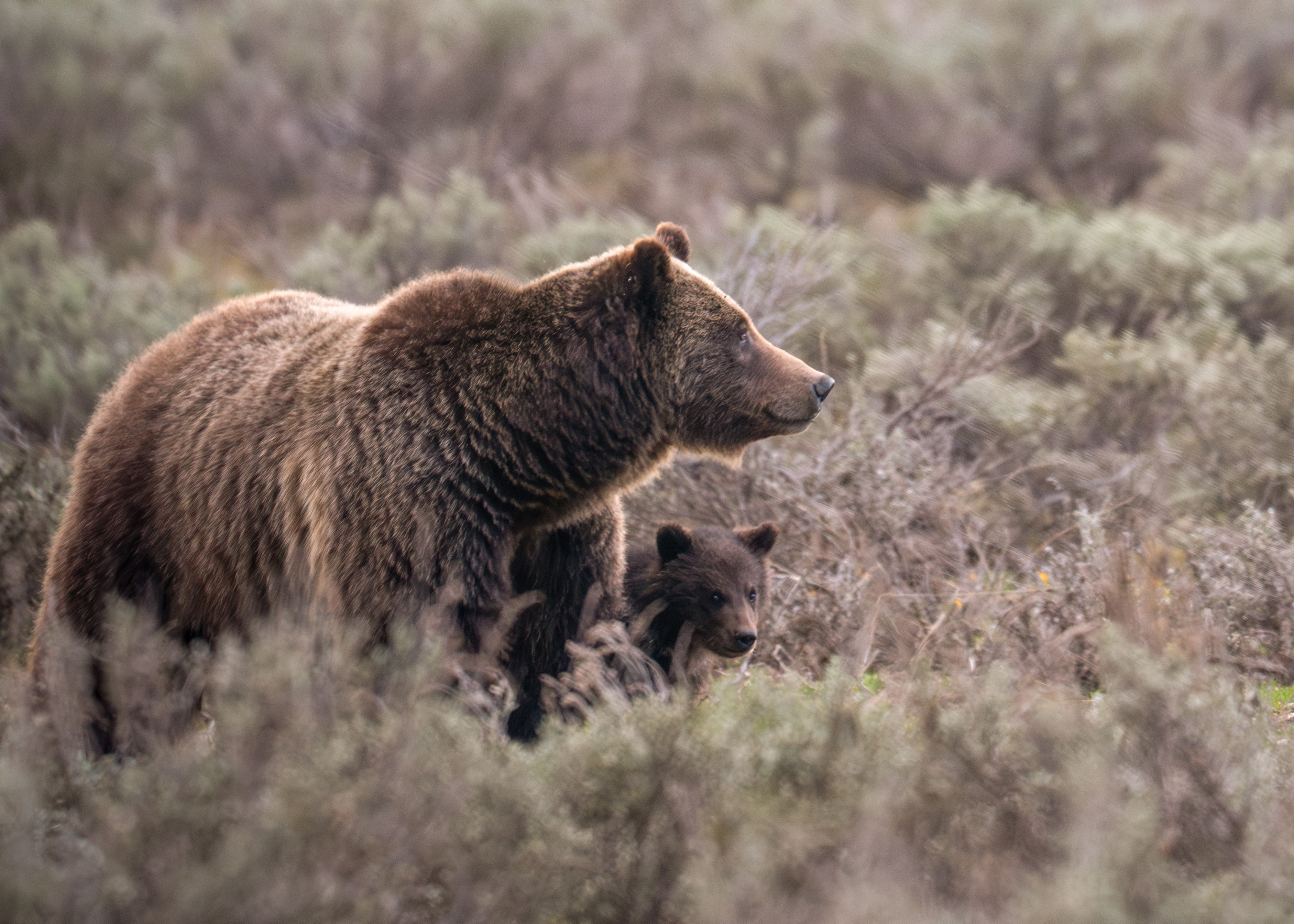 “People from around the world have followed grizzly bear 399 for several decades. At 28 years old, she was the oldest known reproducing female grizzly bear in the Greater Yellowstone Ecosystem,” said Hilary Cooley, Grizzly Bear Recovery Coordinator for the U.S. Fish and Wildlife Service.
“Wildlife vehicle collisions and conflict are unfortunate. We are thankful the driver is okay and understand the community is saddened to hear that grizzly bear 399 has died,” said Angi Bruce, Wyoming Game and Fish Department Director.
“The grizzly bear is an iconic species that helps make the Greater Yellowstone Ecosystem so extraordinary. Grizzly bear 399 has been perhaps the most prominent ambassador for the species. She has inspired countless visitors into conservation stewardship around the world and will be missed,” said Grand Teton National Park Superintendent Chip Jenkins.
No additional information is available at this time.
Background information on grizzly bear/vehicle collisions from the Interagency Grizzly Bear Study Team:
* From 2009-2023, there have been 49 grizzly bear mortalities (all sex and age classes combined) due to vehicle collisions in the Greater Yellowstone Ecosystem.
* Average number of grizzly bear mortalities in the GYE due to vehicle collisions during 2009-2023: 3.3 bears/year.
* In 2024, including this incident, there have been 2 grizzly bear mortalities from vehicle strikes in the GYE.
************************************************************************************
Check out our online trail guides:
Grizzly bear 399 had a yearling cub with her, whose whereabouts are currently unknown. At this time, there is no evidence to suggest the yearling was also involved in the incident, but the US Fish and Wildlife Service is monitoring the area.
Unfortunately, vehicle collisions with wildlife, including grizzly bears, are not uncommon across their range. The Service is working with state and local agencies to gather more information.
“Wildlife vehicle collisions and conflict are unfortunate. We are thankful the driver is okay and understand the community is saddened to hear that grizzly bear 399 has died,” said Angi Bruce, Wyoming Game and Fish Department Director.
“The grizzly bear is an iconic species that helps make the Greater Yellowstone Ecosystem so extraordinary. Grizzly bear 399 has been perhaps the most prominent ambassador for the species. She has inspired countless visitors into conservation stewardship around the world and will be missed,” said Grand Teton National Park Superintendent Chip Jenkins.
No additional information is available at this time.
Background information on grizzly bear/vehicle collisions from the Interagency Grizzly Bear Study Team:
* From 2009-2023, there have been 49 grizzly bear mortalities (all sex and age classes combined) due to vehicle collisions in the Greater Yellowstone Ecosystem.
* Average number of grizzly bear mortalities in the GYE due to vehicle collisions during 2009-2023: 3.3 bears/year.
* In 2024, including this incident, there have been 2 grizzly bear mortalities from vehicle strikes in the GYE.
************************************************************************************
Check out our online trail guides:
- Glacier National Park: HikinginGlacier.com
- Grand Teton National Park: TetonHikingTrails.com
- Rocky Mountain National Park: RockyMountainHikingTrails.com
Wednesday, October 23, 2024
Last day for visitors to enjoy most of Yellowstone National Park will be Oct. 31
The last day for visitors to drive most of Yellowstone National Park’s roads will be Thursday, Oct. 31. The West, South and East entrances and nearly all roads will be closed to regular vehicle traffic Nov. 1. The park annually closes roads at this time of year to prepare them for the winter season and snowmobile and snowcoach travel, which will begin Dec. 15.
Weather permitting, the road from Tower Fall to Canyon Village (Dunraven Pass) will remain open through Oct. 31.
The only roads open year-round are between the North Entrance in Gardiner, Montana, and the Northeast Entrance in Cooke City/Silver Gate, Montana (via Mammoth Hot Springs, Tower Junction and Lamar Valley).
Visitors planning to drive in the park during the fall and winter should: Prepare for changing weather conditions, Have flexible travel plans, Expect limited services, and anticipate possible road closures due to inclement weather and dangerous driving conditions.
All communities near Yellowstone are open year-round, with local businesses offering a wide range of fall and winter recreation opportunities.
************************************************************************************
Check out our online trail guides:
- Glacier National Park: HikinginGlacier.com
- Grand Teton National Park: TetonHikingTrails.com
- Rocky Mountain National Park: RockyMountainHikingTrails.com
Saturday, October 19, 2024
The National Park Service invites you to help reimagine the Taggart Lake experience
The National Park Service wants to hear from you as we consider improvements to the Taggart Lake experience at Grand Teton National Park. This popular year-round trailhead supports a range of recreational pursuits from hiking in summer to skiing and snowshoeing in the winter. Taggart Lake is also a place where visitors of varying physical abilities and hiking familiarity have an opportunity to experience the backcountry. Growing visitation to the trailhead has led to overflow parking, deteriorated trail conditions, trail crowding, vegetation loss and insufficient facilities.
“We are asking people from near and far to weigh in on how we can continue to preserve the park and provide opportunities for high-quality experiences in the Taggart Lake area,” said Grand Teton National Park Superintendent Chip Jenkins.
A public comment period begins today, October 18, and will last through November 21, 2024. The park will host a virtual public meeting on Wednesday, November 13, 2024, from 5 p.m. to 6:30 p.m. MST. For meeting information and to submit your written comments, please visit the project website.
Your comments will help inform the development of alternatives for the Reimagining the Taggart Lake Area planning effort. Alternatives will be analyzed in accordance with the National Environmental Policy Act (NEPA) and the National Historic Preservation Act (NHPA) and will be presented to the public for additional feedback in the future.
The NPS is working in partnership with Grand Teton National Park Foundation, the park’s philanthropic partner, on this project.
************************************************************************************
Check out our online trail guides:
- Glacier National Park: HikinginGlacier.com
- Grand Teton National Park: TetonHikingTrails.com
- Rocky Mountain National Park: RockyMountainHikingTrails.com
Friday, October 11, 2024
Last day for visitors to drive Beartooth Highway (US-212) between Red Lodge and Cooke City, Montana, will be Oct. 14
The last day for visitors to drive the Beartooth Highway (US-212) between Red Lodge, Montana, and Yellowstone National Park’s Northeast Entrance near Cooke City/Silver Gate, Montana, is Monday, Oct. 14. The highway will be closed for the season Oct. 15.
Automobile travel east of Cooke City, Montana, to the Chief Joseph Scenic Byway is possible until early November, weather dependent.
Check the Montana and Wyoming departments of transportation websites for road updates and status.
************************************************************************************
Check out our online trail guides:
- Glacier National Park: HikinginGlacier.com
- Grand Teton National Park: TetonHikingTrails.com
- Rocky Mountain National Park: RockyMountainHikingTrails.com
Thursday, October 10, 2024
Western Wyoming Forests Caution Fire Danger
As unusually dry and warm weather persists across the West, so does fire season for Wyoming public lands. The Shoshone and Bridger-Teton national forests remind outdoor enthusiasts to be cautious while hunting and recreating this fall.
Currently, both the Shoshone and Bridger-Teton forests are in “Very High” fire danger, this means fires can start easily from most causes and may spread rapidly. Small fires can quickly become large fires and exhibit extreme fire behavior, such as long-distance spotting, especially with the windy conditions experienced recently.
The National Multi-Agency Coordination Group has raised the national preparedness level to 5, which is the highest preparedness level. This means firefighting resources are currently extremely scarce. A highly unusual weather pattern is forecast for the next two weeks, with above normal temperatures and dry conditions across the West. Temperatures will likely average 10 to 20 degrees above normal with very low relative humidity.
While most of eastern Wyoming remains under fire restrictions, many areas in western Wyoming are not. Please be aware of local public safety area closures, take precautions before venturing out, and be careful with anything that could start a fire.
“With a little extra effort and caution we can all ensure that human-caused fires are not contributing to the challenging situation we find ourselves in,” states Fred Tucker, Shoshone National Forest Fire Management Officer. “Just like everyone else, we’re all hoping for a significant rain or snow event that will bring the 2024 fire season to a close.”
************************************************************************************
Check out our online trail guides:
- Glacier National Park: HikinginGlacier.com
- Grand Teton National Park: TetonHikingTrails.com
- Rocky Mountain National Park: RockyMountainHikingTrails.com
Tuesday, October 8, 2024
Yellowstone researchers discover cause of July's Biscuit Basin explosion
The USGS Volcanoes posted this bit of news regarding the Biscuit Basin explosion in Yellowstone on their social media recently:
************************************************************************************
Check out our online trail guides:
Let’s get you caught up on what we’ve learned about the July 23, 2024, hydrothermal explosion in Biscuit Basin, in this #Yellowstone Volcano Observatory Monthly Update for October 2024.Here's a short video with more information:
On July 23, 2024, there was an explosion from Black Diamond Pool at Biscuit Basin in Yellowstone National Park. Since that time since, we've learned quite a lot about this event.
The explosion was not caused by the direct interaction of magma and water, with magma causing water to flash to steam. Rather, the explosion was caused by the accumulation of boiling water and steam at shallow levels. We know it was shallow because the rocks that came out during the explosion are glacial debris - sandstone and siltstone - that are sourced at very shallow levels. None of the rock is rhyolite from bedrock that's about 175 feet beneath the surface.
The seismometers, cameras, and thermal probes that were put out after the explosion have detected surges of water from Black Diamond Pool. The surges haven’t been big, but they have moved rocks around and deposited silt on the shores of the pool. From citizen science reports and photographs prior to the explosion, we’ve learned that there may have been a precursory surge from the pool, probably on the night of July 16 or 17, based on how rocks moved around between those two time periods.
So, we've learned quite a bit about this previously underappreciated hazard (hydrothermal explosions) which are the most likely hazard to occur in the Yellowstone Region on human timescales.
During the month of September 2024, the University of Utah Seismograph Stations, which monitors and operates the Yellowstone seismic network, located 54 earthquakes, which is consistent with background levels of activity. Deformation trends observed since 2015 continue with a seasonal pause in subsidence. While Steamboat Geyser did not have a water eruption in September, frequent minor activity suggests that an eruption is likely in the coming days to weeks.
Yellowstone Volcano remains at normal, background levels of activity.
************************************************************************************
Check out our online trail guides:
- Glacier National Park: HikinginGlacier.com
- Grand Teton National Park: TetonHikingTrails.com
- Rocky Mountain National Park: RockyMountainHikingTrails.com
Monday, October 7, 2024
Bridger-Teton Seeks Input on Commissary Ridge Trails
The Bridger-Teton National Forest is beginning a multi-year project to improve the Commissary Ridge Trail System in the southern Wyoming Range and is asking for your input.
The Commissary Ridge Trail System is 180 miles of backcountry multi-use non-motorized trails on the Kemmerer Ranger District in Southwest Wyoming. With 34 different trails and 17 trailheads, the Commissary Ridge Trail System is a paradise for outdoor enthusiasts.
The trail system has been largely unmaintained for over two decades. Natural factors such as erosion, fallen trees, fire, and overgrowth have taken a toll on the trails, making some sections unsafe and difficult to navigate. This overall decline in the quality of the trail system has negatively impacted the visitor experience.
In response to this critical need, the Kemmerer Ranger District is proposing a three-year project to revitalize and enhance the trail system. The project aims to restore and improve the existing trails, making them safer and more enjoyable for visitors.
The first phase of the project is to inventory the expansive trail system to identify areas of concern. The second phase will be the on-the-ground restoration of both trails and trailheads.
The project is a collaborative effort between the Forest Service, state and non-governmental partners, local communities, and volunteers. It highlights the importance of responsible and sustainable recreational use of public lands.
The Kemmerer Ranger District is seeking peoples’ knowledge and desires for the Commissary Ridge Trail System. Everyone is encouraged take a few moments to complete the brief questionnaire. Feedback received will help managers make informed decisions on how best to move forward with the renovation project.
For more information you can call 307-739-5500 or visit https://www.fs.usda.gov/
************************************************************************************
Check out our online trail guides:
- Glacier National Park: HikinginGlacier.com
- Grand Teton National Park: TetonHikingTrails.com
- Rocky Mountain National Park: RockyMountainHikingTrails.com
Saturday, October 5, 2024
Flathead National Forest conducts National Visitor Use Monitoring survey
The National Visitor Use Monitoring (NVUM) surveys began this week and will be conducted across the Flathead National Forest through September 30, 2025. The primary function of the survey is to gauge National Forest visitor satisfaction. It provides National Forest managers with an estimate of how many people recreate on the Flathead National Forest, what activities they engage in while there, and how satisfied people were with their visit. Surveys are voluntary and all responses are confidential; names are not included. Interviews include basic visitor information and last about 10 minutes.
Visitors to Flathead National Forest will encounter Forest Service employees conducting interviews in developed and dispersed recreation sites and along Forest Service roads. They will be out in all types of weather conditions, wearing bright orange vests, and will be near a sign that says, “Traffic Survey Ahead”.
“Although the survey is entirely voluntary, participation is extremely important so we can assess visitor experiences on the Forest and strive to make it a better place to visit,” said Forest Supervisor Anthony Botello. “We would appreciate it if visitors would pull over and answer a few questions. We would like to hear from local people using the forest, as well as out-of-area visitors, so all types of visitors are represented in the study.”
Additional information about the National Visitor Use Monitoring program can be found at: https://www.fs.usda.gov/about-agency/nvum
************************************************************************************
Check out our online trail guides:
- Glacier National Park: HikinginGlacier.com
- Grand Teton National Park: TetonHikingTrails.com
- Rocky Mountain National Park: RockyMountainHikingTrails.com
Thursday, October 3, 2024
Fire Danger Increased to Very High in Grand Teton
Teton Interagency Fire managers have elevated the fire danger rating to “Very High” for Grand Teton National Park, Bridger-Teton National Forest and the National Elk Refuge. When the fire danger is "Very High," fires can start easily from most causes and may spread rapidly with quick increase in intensity right after ignition. Small fires can quickly become large fires and exhibit extreme fire intensity, such as long-distance spotting. These fires can be difficult to control and can often become much larger and longer lasting.
Last week, six human-caused fires were reported on the Bridger-Teton National Forest. These fires, all from abandoned warming fires, have ranged in size from ½ acre to 4.5 acres. Luckily, all these fires have been extinguished thanks to the vigilance of public reporting and firefighters patrolling the Forest. Fire managers are urging recreationists to use extreme caution with fire.
During the fall, frost kills summer grasses and vegetation, creating more light, cured fuels to carry fire. Larger fuels remain dry throughout the season, and winds become a major driver for fires. Additionally, with fall, comes the arrival of hunting season. People hunting and recreating on public lands will want to have warming fires and campfires with the cooler overnight temperatures. Public land users can help prevent wildfires by choosing to not have a fire at all and instead dress for success with multiple layers and warm clothing.
Unseasonably warm daytime temperatures and very dry conditions are predicted to continue over the weekend and into next week with periods of increased wind and no forecasted rain.
Fire managers advise recreationists to use extreme caution if choosing to build and maintain a campfire. In areas where campfires are allowed, fires should never be left unattended and must be completely extinguished before leaving. If choosing to have a campfire, keep it small and have a plan for putting it out before lighting it. All recreationists should have a shovel on hand and a water bucket ready for use. Soak, stir, feel, repeat. Make sure your campfire is “dead out” and cold to the touch before leaving. If it's too hot to touch, it's too hot to leave!
To date, 68 campfires have been abandoned or left unattended in the Teton Interagency Dispatch area. Unattended or abandoned campfires and warming fires can quickly escape and become wildfires, and recreationists can be held liable for suppression costs.
Visit the Teton Interagency Fire website at TetonFires.com to learn more about fire safety. To report a fire or smoke in the area, call Teton Interagency Fire Dispatch Center at 307-739-3630.
************************************************************************************
Check out our online trail guides:
- Glacier National Park: HikinginGlacier.com
- Grand Teton National Park: TetonHikingTrails.com
- Rocky Mountain National Park: RockyMountainHikingTrails.com
Wednesday, October 2, 2024
Public Invited to Mount Brown Hawk Watch Event
Glacier National Park will host its annual Mount Brown Hawk Watch Program on October 5th from 11 am - 3 pm near Lake McDonald Lodge.
The event will be held at the Golden Eagle interpretative sign near Jammer Joe’s parking lot, beginning at 11 am. Park biologists will teach volunteers how to identify and count migrating raptors. Educators from Montana Wild Wings Recovery Center will also be on site with live raptors from 12 pm - 2 pm to provide a close-up on raptor species that migrate past Mount Brown.
For the last hour of the event, counting migrating raptors will resume from 2 to 3 pm. Participants should bring their own binoculars, (there will be a small number provided) and be prepared to count Golden Eagles on their annual migration south past Mount Brown. Biologists, park staff and volunteers will be on hand to answer questions about the integral role of raptors in our ecosystems, the risks they face, and why Glacier has started the Mount Brown Hawk Watch Program. Attendees do not need to stay for the whole time; snacks and hot beverages will be provided.
Beginning September 23 through October, volunteers can also choose to count migrating raptors from the Jammer Joe’s parking lot at Lake McDonald Lodge from noon to 4 pm each day, or hike on their own to count migrating raptors just below Mount Brown fire lookout. The hike to the Mount Brown observation point is about 4.5 miles/7.2 km one-way (about 9 miles/14.5 km roundtrip) with an elevation gain of over 4,000 ft/1,220 m. Volunteers interested in hiking to the observation point and participating in the count should email the Glacier Citizen Science Office, e-mail us, for additional details.
Each year in the fall, Golden Eagles migrate from northern breeding grounds to warmer climates. One of the most important North American Golden Eagle migration routes passes directly through Glacier National Park along the Continental Divide. Many other raptors also use this migration corridor during the fall and spring months.
In the mid-1990s biologists documented nearly 2,000 Golden Eagles migrating past Mount Brown annually. Recent data from outside Glacier National Park indicates a significant decline in Golden Eagle numbers. Due to this concern, the park initiated a Citizen Science Raptor Migration Project in 2011 to investigate possible locations for a Hawk Watch site. Hawk Watch sites are part of an international effort to track long-term raptor population trends using systematic migrating raptor counts. Observers also record data on sex, age, color morph and behavior of raptors, as well as weather and environmental conditions. To see a map of Hawk Watch sites around the world on the HawkCount website.
Glacier National Park Conservancy donors provide support for this program. Contact e-mail us or call (406) 888-7986 for more information.
************************************************************************************
Check out our online trail guides:
- Glacier National Park: HikinginGlacier.com
- Grand Teton National Park: TetonHikingTrails.com
- Rocky Mountain National Park: RockyMountainHikingTrails.com
Tuesday, October 1, 2024
Southern Appalachia Desperately Needs Your Help
Yesterday, Kathy and I returned from our trip to Rocky Mountain National Park. As some of you may know, we moved to to a small community just north of Great Smoky Mountains National Park in East Tennessee a little over three years ago. If I remember correctly, news that Hurricane Helene was approaching the Florida coast reached us on Thursday, and that the track of the storm was expected to pass near our home. Naturally, we were more than a little concerned. Though we expected some damage to the area, we never dreamed that it would become one of the most devastating natural disasters in American history. Fortunately for us, the storm spared our small community. However, several towns in our immediate area were completely devastated. I'm writing this blog in hopes that some of you will help the people in this region whose lives have been turned upside down. Many of these people have lost everything - their homes, businesses and jobs. Some have even lost their lives. There are still homes, communities and towns that are completely cut-off from the rest of this world. Numerous roads have been washed out, including both I-40 and I-26 near the TN-NC border (on either side of Asheville, NC). Numerous bridges have also been destroyed. Power is still out for millions of people in TN, NC, SC, GA and FL. I just read an AP story that volunteers are using mules "to deliver food, water and diapers to hard-to-reach mountainous areas".
Most importantly, at this very moment, there are immediate needs, such as water. Our community has organized at least two truckloads of bottled water that have been sent to Greeneville and Newport, TN. I'm sure we'll be doing much more over the next days, weeks and months. For those who can't physically provide relief, donations are also extremely appreciated / needed.
As the region waits for FEMA and other Federal agencies to respond en masse, there are many ways you can help right now. The Tennessee Voluntary Organizations Active in Disaster is taking monetary donations. Second Harvest of East Tennessee is accepting monetary donations to provide food relief. The Community Foundation of Western North Carolina also seeks donations for relief in western NC. Samaritan's Purse is already on the ground in five locations. And of course, the Red Cross is the most well-known organization. These are just some of the ways you can help. There are many more here, here and here.
To possibly personalize the story a little more for this audience, I wanted to provide some additional information from the hiker perspective. Several Appalachian Trail communities ("trail towns") have been virtually destroyed. This includes Hot Springs, NC, Erwin, TN, Roan Mountain, TN and Damascus, VA. As you may have guessed, the Appalachian Trail has also been devastated. Right now, the southern third of the trail, from Springer Mountain, GA to Rockfish Gap, VA is effectively closed. That's 865 miles of trail that were impacted. You can visit this ATC page for ways you can help.
Several roads, and likely much of the trail system in Great Smoky Mountains National Park is currently closed. On their website, the park states, "outdoor recreation is currently discouraged due to park staffing being stretched and visitor safety concerns." On another page, they posted this statement:
Though their website hasn't been updated since September 26th, I would imagine much of the Blue Ridge Parkway is closed. Mount Mitchell State Park, Gorges State Park and Grandfather Mountain are all closed. Much of Nantahala and Pisgah National Forests are also closed as well.
Here are a few stats from the storm, provided by NOAA:
* MOUNT MITCHELL reported maximum winds of 106 MPH.
* BUSICK NC received 30.78 inches of rain.
* MOUNT MITCHELL STATE PARK received 24.20 inches of rain.
As you can see from this map, western NC received the brunt of this storm once it reached inland:
 There are likely thousands of pictures of destruction from the storm. All of them tell a story, but none tell the full story. I'll post one from Hot Springs, a town that we visited just a few weeks ago as we were training for our hikes in Colorado:

Most importantly, at this very moment, there are immediate needs, such as water. Our community has organized at least two truckloads of bottled water that have been sent to Greeneville and Newport, TN. I'm sure we'll be doing much more over the next days, weeks and months. For those who can't physically provide relief, donations are also extremely appreciated / needed.
As the region waits for FEMA and other Federal agencies to respond en masse, there are many ways you can help right now. The Tennessee Voluntary Organizations Active in Disaster is taking monetary donations. Second Harvest of East Tennessee is accepting monetary donations to provide food relief. The Community Foundation of Western North Carolina also seeks donations for relief in western NC. Samaritan's Purse is already on the ground in five locations. And of course, the Red Cross is the most well-known organization. These are just some of the ways you can help. There are many more here, here and here.
To possibly personalize the story a little more for this audience, I wanted to provide some additional information from the hiker perspective. Several Appalachian Trail communities ("trail towns") have been virtually destroyed. This includes Hot Springs, NC, Erwin, TN, Roan Mountain, TN and Damascus, VA. As you may have guessed, the Appalachian Trail has also been devastated. Right now, the southern third of the trail, from Springer Mountain, GA to Rockfish Gap, VA is effectively closed. That's 865 miles of trail that were impacted. You can visit this ATC page for ways you can help.
Several roads, and likely much of the trail system in Great Smoky Mountains National Park is currently closed. On their website, the park states, "outdoor recreation is currently discouraged due to park staffing being stretched and visitor safety concerns." On another page, they posted this statement:
"Hiking and backcountry travel are not recommended in the park following Hurricane Helene impacts. Park staff are assessing trail conditions and addressing damage, but unpredictable creek crossings, potential downed trees, and other hazardous trail conditions remain. Emergency response times may be delayed with staff stretched thin and resources limited."High On Leconte is reporting that Mount Leconte received 10.35 inches of rain during the storm, with maximum winds clocked at 65 MPH. They are also reporting that the TN side of the park seems to have escaped much of the damage. However, that side was on the lee side of the storm, and was protected by the crest of the mountains. My guess is that the NC side, and the eastern portion of the park is in very bad shape right now.
Though their website hasn't been updated since September 26th, I would imagine much of the Blue Ridge Parkway is closed. Mount Mitchell State Park, Gorges State Park and Grandfather Mountain are all closed. Much of Nantahala and Pisgah National Forests are also closed as well.
Here are a few stats from the storm, provided by NOAA:
* MOUNT MITCHELL reported maximum winds of 106 MPH.
* BUSICK NC received 30.78 inches of rain.
* MOUNT MITCHELL STATE PARK received 24.20 inches of rain.
As you can see from this map, western NC received the brunt of this storm once it reached inland:


Subscribe to:
Comments (Atom)