Last week Secretary of the Interior Ken Salazar and National Park Service Director Jon Jarvis announced the release of the final General Management Plan/Environmental Impact Statement for the South Unit of Badlands National Park, recommending the establishment of the nation’s first tribal national park in partnership with the Oglala Sioux Tribe.
The South Unit of Badlands National Park is entirely within the Pine Ridge Indian Reservation in southwestern South Dakota. The Park Service and the Tribe have worked together to manage the South Unit’s 133,000 acres for almost 40 years. If a tribal national park is enabled by Congress through legislation, the Oglala Sioux people could manage and operate their lands for the educational and recreational benefit of the general public, including a new Lakota Heritage and Education Center.
The GMP/EIS reflects the goals of the National Park Service’s recently released “A Call to Action” plan for the Service’s next 100 years that emphasizes a system of parks and protected sites that more fully represent our nation’s natural resources, history and cultural experiences. The tribal national park would seek to promote an understanding of Oglala Sioux history, culture, and land management principles through education and interpretation.
The National Park Service, Oglala Sioux Tribe, and the Oglala Sioux Parks and Recreation Authority have been cooperatively developing the GMP/EIS for the South Unit of Badlands National Park since early 2006. The management plan acknowledges the important partnership between the National Park Service and Oglala Sioux Tribe and establishes a common vision for managing resources and visitor use in the South Unit.
Under the plan, the National Park Service and the Tribe will focus on restoring the health and vibrancy of the prairie to enhance wildlife habitat, expanding bison into the South Unit, providing roads and trails and providing greater opportunities for visitors to experience the natural grandeur of the South Unit and the heritage of the Oglala Sioux people.
The National Park Service is expected to sign the Record of Decision for the GMP/EIS this summer; however, congressional legislation is necessary before the Service can implement the Plan’s Preferred Management Option. In the meantime, the Park Service and Tribe may prepare for and implement appropriate parts of the plan and identify the components of a tribal national park that need to be addressed by legislation.
Depending on Congressional action, the South Unit could be administered through a variety of options, including as a unit of the National Park System managed by tribal members hired as NPS employees, or managed by tribal members as employees of the Tribe. The plan proposes no change in overall responsibility or management absent Congressional legislation.
During World War II, the War Department established the Pine Ridge Aerial Gunnery Range from lands within the Reservation. In 1968, the Gunnery Range was declared excess, and Congress conveyed most of the lands to the Tribe with the provision that the South Unit be administered by the National Park Service. In 2003, the Tribe formally requested government-to-government negotiations regarding management control of the South Unit, and the Park Service, the Bureau of Indian Affairs and the Tribe agreed to use the general management plan process to explore options for greater involvement in the South Unit.
Jeff
Hiking in Glacier.com

Monday, April 30, 2012
Sunday, April 29, 2012
Win a Trip to Glacier thru See More On A Train Contest
Train passengers experience travel unlike any others; they get to see the vastness of the American landscape more intimately when traveling by rail, from cities big and small, to country vistas and everything in between. In honor of the fifth anniversary of National Train Day, Amtrak is inviting train fans to share what they see and experience on their train journeys and enter the See More On A Train online contest.
A celebration of train travel and the ways that trains touch the lives of people across America, National Train Day will take place at train stations in New York City, Philadelphia, Chicago, and Los Angeles, as well as numerous other communities throughout the nation, on Saturday, May 12, 2012. Award-winning actress, writer and philanthropist, Rosario Dawson, will serve as spokesperson for the Fifth Annual National Train Day, sharing her love of train travel and how it allows her to be involved in the community in a more personal way with train fans.
From now through May 29, 2012, train fans can upload their original photos, videos and stories chronicling how they have been inspired by their train travel to NationalTrainDay.com for the chance to win great prizes. A Grand Prize winner in each of the three categories will have their choice of one of four provided Amtrak Vacations Tour Packages for two travelers.
In addition, train fans can visit facebook.com/NationalTrainDay to participate in the National Train Day sweepstakes for the chance to win an Amtrak Vacations Package to Glacier National Park and a full Samsonite luggage set.
To view the complete rules for the See More On A Train online contest and additional prizing information, or to learn more about National Train Day, please visit NationalTrainDay.com.
Jeff
Hiking in Glacier.com
Saturday, April 28, 2012
FWP To Begin Bison Management Plan Discussions
Earlier this week Montana Fish, Wildlife & Parks announced that they will be hosting a series of public meetings this spring as a first step toward developing a long-term bison conservation and management plan for the state. The plan will be developed through a programmatic environmental impact statement, which will address issues associated with bison and options for their long-term management as a Montana wildlife species.
The programmatic EIS, which will take about three years to complete, will examine an array of issues and possible alternatives—including no action—and each alternative’s potential beneficial and adverse environmental, social, and economic impact.
FWP will begin a formal public “scoping” process as required under the Montana Environmental Policy Act. Public scoping is aimed at identifying issues, impacts, public concerns, and conservation challenges and opportunities. The comments will assist FWP in further identifying issues and developing possible alternatives.
Some issues already identified include: (1) the risk of bison spreading disease to domestic livestock, (2) competition between bison and other wildlife, (3) competition between bison and livestock for rangeland, (4) damage to fencing, (5) public safety, and (6) the legal classification and status of bison in Montana.
Eight scoping meetings are scheduled for May. The sessions will be held from 6-9 p.m., with the first hour dedicated to informal discussions and the remainder of the evening set for recording scoping comments. Here are the meeting dates and locations:
May 14 - Missoula Holiday Inn Downtown – 200 S. Pattee St.
May 15 - Kalispell Red Lion Hotel – 20 N. Main St.
May 16 - Glasgow Cottonwood Inn – 45 1st Ave NE
May 17 - Helena Montana Wild Center – 2668 Broadwater Ave.
May 21 - Billings Holiday Inn Grand MT Convention Center – 5500 Midland Rd.
May 22 - Miles City BLM conference room, BLM center – 111 Garryowen Rd.
May 23 - Great Falls Townhouse Inn – 1411 10th Ave. S.
May 24 - Bozeman Holiday Inn on Baxter – 5 Baxter Lane
Last year, in anticipation of a programmatic EIS proposal, FWP prepared a summary of bison history and activities in the West that offers information related to the possible restoration of bison in Montana. The “Bison Background Document” presents information on the bison's genetic and disease history, management concerns and a brief synopsis of different bison management philosophies among an array of private groups and organizations. The document is available online here. The document may also be obtained on CD or other formats by calling Margaret Morelli at 406-994-6780 or via email at MMorelli@mt.gov.
Jeff
Hiking in Glacier.com
National Park Stat of the Day
According to a release from the the National Park Office of Communications, there are 18,600 miles of trails in our national parks.
That means, with roughly 740 miles, Glacier National Park contains 4% of all the trail mileage in our national parks!
Jeff
Hiking in Glacier.com
That means, with roughly 740 miles, Glacier National Park contains 4% of all the trail mileage in our national parks!
Jeff
Hiking in Glacier.com
Friday, April 27, 2012
Many Glacier Road is now open!
Plows continue to make progress on snow removal throughout Glacier National Park. The latest update on the Glacier website reports that the West Lakes Road Crew has reached the Haystack Creek drainage area (4.5 miles below Logan Pass) on the west side of the Divide. The crew has encountered snow depths of 6 to 20 feet deep. The Hudson Bay Road Crew, located on the east side of the park, has cleared snow to Dead Horse Point, 9.5 miles east of Logan Pass, and has encountered snow depths of 10 feet.
On the west side of the Divide the Going-to-the-Sun Road is open from the West Entrance to the Lake McDonald Lodge. On the east side the road to open to Rising Sun.
The update also mentions that Many Glacier Road is now open, the Two Medicine Road is open to Running Eagle Falls, Camas Road is open, and Kintla Road is open to Big Prairie.
For a complete update, please click here.
The photo below was taken near the Haystack Creek area:

To view all of the latest snow clearing photos, visit the Glacier Photo Page on Flickr.
Jeff
Hiking in Glacier.com
On the west side of the Divide the Going-to-the-Sun Road is open from the West Entrance to the Lake McDonald Lodge. On the east side the road to open to Rising Sun.
The update also mentions that Many Glacier Road is now open, the Two Medicine Road is open to Running Eagle Falls, Camas Road is open, and Kintla Road is open to Big Prairie.
For a complete update, please click here.
The photo below was taken near the Haystack Creek area:
To view all of the latest snow clearing photos, visit the Glacier Photo Page on Flickr.
Jeff
Hiking in Glacier.com
Trail Days
Next month is Trail Days in Damascus, Virginia.
Trail Days is the annual Woodstock for hikers. It’s the mother of all hiking gatherings. It’s a celebration of all things Appalachian Trail. And it all happens in tiny Damascus, Virginia, also known as Trail Town, USA where the Appalachian Trail, the Virginia Creeper and the Iron Mountain Trail slice through the middle of town. Each year Damascus becomes the destination point for thousands of thru-hikers, veteran hikers and those who just love hiking and the Appalachian Trail. It's recognized as the largest trail event in the world, and many A.T. thru-hikers will time their hike in order to be in town in mid-May for the annual three day festival.
In honor of the biggest and best hiker festival in the world, here's a short film, produced by Broadcast Your Adventure Films (part of thebackpacker.tv), to give you an idea of what Trail Days is all about:
Jeff
Hiking in Glacier.com
Trail Days is the annual Woodstock for hikers. It’s the mother of all hiking gatherings. It’s a celebration of all things Appalachian Trail. And it all happens in tiny Damascus, Virginia, also known as Trail Town, USA where the Appalachian Trail, the Virginia Creeper and the Iron Mountain Trail slice through the middle of town. Each year Damascus becomes the destination point for thousands of thru-hikers, veteran hikers and those who just love hiking and the Appalachian Trail. It's recognized as the largest trail event in the world, and many A.T. thru-hikers will time their hike in order to be in town in mid-May for the annual three day festival.
In honor of the biggest and best hiker festival in the world, here's a short film, produced by Broadcast Your Adventure Films (part of thebackpacker.tv), to give you an idea of what Trail Days is all about:
Trail Days Documentary from thebackpackertv on Vimeo.
Jeff
Hiking in Glacier.com
Thursday, April 26, 2012
New Exhibit: Mountaineering in Glacier
A new exhibit at the Museum at Central School in Kalispell traces the rich history of mountaineering in Glacier National Park.
 Open now through March of 2013, the exhibit traces the adventure-filled history of mountain climbing and hiking in Glacier National Park, along with the activities of the exhibit’s creator, the Glacier Mountaineering Society. The display is part of an on-going partnership with the First Best Place Task Force’s Discovery Square in Columbia Falls and the Museum at Central School in Kalispell.
Mountaineering in Glacier offers an in-depth look at the history of mountaineering in Glacier through a video presentation, photographs, old newspaper stories and a rock wall built to display the gear used for mountaineering.
An opening reception for the exhibit will occur on Friday, May 4 from 5-7 p.m.
For more information on the exhibit or the Museum at Central School, click here or call 406-756-8381.
Jeff
Hiking in Glacier.com
Wednesday, April 25, 2012
GNP Hosts First Brown-Bag Lecture of the Year
The Crown of the Continent Research Learning Center at Glacier National Park is hosting a brown-bag lecture on Wednesday, May 2, from 12- 1 p.m. at the Community Building in West Glacier. The public is invited to join Dr. Cristina Eisenberg present her recently completed doctoral dissertation, The Complex Food Web of Fire, Aspen, Elk, and Wolves in Waterton-Glacier International Peace Park.
Dr. Eisenberg is a recent Ph.D. graduate from Oregon State University and her research has focused on the impacts of predator presence on prey behavior and how the food chain interacts with fire to shape vegetation communities in Waterton-Glacier International Peace Park
She has a post-doctoral appointment at Oregon State University, where she will continue her work on fire, aspen, elk, and wolves in the park. For her master's degree in environmental studies at Prescott College, she studied wolf ecology and management, with a focus on the work of Aldo Leopold.
Her first book, The Wolf's Tooth: Keystone Predators, Trophic Cascades and Biodiversity, was published in 2010. She is working on her second book, about the ecology and public policy underlying large carnivore conservation in the West.
Dr. Eisenberg is the research director on the High Lonesome Ranch in north-central Colorado, where her research interests involve living sustainably with large carnivores and utilizing food web concepts to restore ecosystems.
This brown-bag lecture and other lectures throughout the year are hosted by Glacier National Park's Crown of the Continent Research Learning Center. For more information about the center, please call 406-888-7863 or click here.
Jeff
Hiking in Glacier.com
The Best Lake Hikes in Glacier National Park
As a result of its topography, as well as the heavy amounts of snow that fall during the winter, Glacier National Park is home to 762 lakes. Lake McDonald, on the western side of the park, is the largest in area at 6,823 acres, the longest at 9.4 miles, and the deepest at 464 feet. Most lakes in the park, however, are much smaller. In fact, only 131 lakes actually have a name, including "No Name Lake" in the Two Medicine area.
Fortunately for hikers, many of the trails in Glacier Park lead to, or end at a lake. Below are a few of my favorites:
Cracker Lake - Cracker Lake in the Many Glacier area has to be one of the most beautiful lakes in the world. The lake has the most magnificent turquoise color you’ll ever see. If you could ignore the magnificent scenery of the surrounding mountains, it would still be well worth the hike just to see the amazing color of the lake.
 Iceberg Lake - One of the most popular hikes in Glacier. And for good reason. This is a great opportunity to see icebergs floating in a gorgeous alpine lake. You’ll also have commanding views of the Ptarmigan Wall, an arête, or thin ridge of rock separating two valleys that have been carved by glaciers.
Gunsight Lake – A great hike if you’re looking for solitude. In addition to visiting an extremely beautiful alpine lake, you'll also pass Mirror Pond along the way, which just might be one of the most scenic spots in the entire park.
Swiftcurrent Nature Trail - Take an easy stroll around Swiftcurrent Lake for some outstanding views of the Many Glacier Valley. As a bonus, you may even see a bear or a moose along the way.
Hidden Lake - This extremely popular hike, starting from Logan Pass, visits the Hidden Lake Overlook where you’ll have outstanding panoramic views into the heart of Glacier. This hike would’ve definitely ranked higher if it weren’t for the crowds.
 Redrock Lake - An outstanding choice for an easy hike. The trail visits two picturesque sub-alpine lakes. Look for moose feeding near the shore of Fishercap Lake.
Cobalt Lake – The trail to the lake travels through several open meadows in the Two Medicine valley. Along the way you’ll pass Rockwell Falls, and you might even see a moose.
Avalanche Lake – The hike to Avalanche Lake begins on the Trail of the Cedars where you’ll pass though a forest of ancient western hemlocks and red cedars. You’ll also see the amazing power of glacially melted water as it rushes down Avalanche Gorge.
Snyder Lake – Great choice for a hike from the Sperry Trailhead near the Lake McDonald Lodge, especially if you’ve already been to the Sperry Chalet, and have no desire to make the 4250-foot climb up to the Mt. Brown Lookout.
Upper Two Medicine Lake – An easy hike to the highest in a series of three glacially fed lakes that dominate the Two Medicine Valley. The lake sits in a large basin surrounded by the jagged rocks of four mountains.
Jeff
Hiking in Glacier.com
Tuesday, April 24, 2012
Participation in Outdoor Recreation Reaches Highest Level in Five Years
In 2011, more Americans participated in outdoor recreation activities than in the past five years – perhaps signaling a move toward healthier, active lifestyles. More than 141 million Americans, or 49.4 percent of the U.S. population, participated in outdoor activities last year – reflecting an increase of three million people compared to 2010 and continuing a five-year trend. In addition, Americans made a total of 11.6 billion outdoor outings in 2011, which is 1.5 billion more than the previous year. Annually, participants averaged 82 outdoor outings – from hiking to biking, skiing to paddling. The findings are part of the 2012 Outdoor Recreation Participation Topline Report, the leading report tracking outdoor participation trends in United States published by The Outdoor Foundation.
The research shows increases in youth and young adult participation – continuing an encouraging, yet modest, trend over the last few years. The study found that outdoor participation increased by one-percentage in every age bracket, 6 to 12, 13 to 17 and 18 to 24 respectively. This accounted for more than four billion outdoor outings for the younger generation with an annual average of nearly 90 outdoor outings. While encouraging, these rates are significantly lower than those recorded in 2006. For example, 63 percent of youth ages 6 to 12 participated in outdoor recreation in 2011, compared to 78% in 2006.
The most popular activities among young people, in terms of overall participation, continued to be running, biking, camping (20.6%), fishing and hiking (12.9%). Skateboarding, triathlons and bird-watching were among their top five favorite activities as measured by frequency.
 Interestingly, adults share a passion for similar recreational pursuits. The following are the participation rates for the top 5 outdoor activities among adults older than 25:
1. Fishing (15.1%)
2. Running/Jogging/Trail Running (14.8%)
3. Camping (12.7%)
4. Bicycling (12.4%)
5. Hiking (11.8%)
In terms of growth over the prior year, hiking ranked 10th among all outdoor activities, which reported a 6% increase over the prior year. Kayaking, which ranked 1st, jumped 27% over 2010. Another interesting statistic occurred in backpacking. The activity seemed to be going through a revival of sorts between 2008 and 2010, but dropped off sharply in 2011.
Published annually by The Outdoor Foundation with research support from the Department of Recreation, Park & Tourism Sciences at Texas A&M University, the 2012 Outdoor Recreation Participation Topline Report is derived from almost 40,000 online interviews conducted in January 2012/early February 2012. Respondents came from a nationwide sample of individuals and households from the U.S. Online Panel operated by Synovate. Over-sampling of ethnic groups took place to boost response from typically under-responding groups.
The 2012 Outdoor Recreation Participation Topline Report is available here. According to the press release, detailed information concerning all the trends in the 2012 Outdoor Recreation Participation Report will be released soon.
Jeff
Hiking in Glacier.com
Vote For Me!
Hey everyone, I just entered a photo (below) in the Glacier National Park Facebook cover photo contest. I would really appreciate if you could click on this link, and then "Like" my photo!

Jeff
Hiking in Glacier.com

Jeff
Hiking in Glacier.com
Monday, April 23, 2012
Discount Lodging Offer for Friends of Yellowstone Park Foundation
Late last week the Yellowstone Park Foundation announced that if you make a contribution to the Foundation by June 30, 2012, you will receive a coupon for 20% off regular room rates at Yellowstone National Park Lodges (Xanterra Parks & Resorts).
The lodging discount applies to the following date ranges: May 4 - 31, 2012 and October 1- 20, 2012
Jeff
Hiking in Glacier.com
The lodging discount applies to the following date ranges: May 4 - 31, 2012 and October 1- 20, 2012
Jeff
Hiking in Glacier.com
Saturday, April 21, 2012
Prescribed Burning Planned for Several Ranger Districts in the Lolo National Forest
Ranger Districts across the Lolo National Forest will ignite prescribed burns beginning tomorrow if fuel, weather, and air quality conditions allow for safe and effective burning. If burning takes place smoke from the Ninemile and Missoula Ranger District burns will be visible from Missoula. Smoke from burns on the Ninemile district on Sunday and Monday will be visible from Interstate-90.
On Sunday the Missoula Ranger District may ignite a burn of approximately 60 acres near the Motorcycle Trailhead at the Blue Mountain Recreation Area. The burn location (T12N R20W SW1/4 Section 4) is about two miles west of the main Blue Mountain Trailhead (and adjacent to under-burning accomplished two weeks ago). The burn is intended to reintroduce low intensity surface fire to the area, reduce surface fuel concentrations, promote ponderosa pine re-generation, and rejuvenate forest floor vegetation. The burn will likely be ignited by hand and fire managers expect to complete the burn in about four hours. Smoke will be visible from Missoula and the Hayes Creek area.
For the Blue Mountain burn road signs will be posted along Blue Mountain and Hayes Creek roads. To ensure public safety, recreationists are advised to use caution on adjacent roads and be aware of fire operations along Forest Road 365. During the ignition period there will be limited access to portions of forest trails south of the Motorcycle Trailhead.
The Missoula Ranger District also plans to ignite a prescribed burn in the Rock Creek drainage southeast of Missoula on Monday, April 23. The Butte Cabin Creek Ecosystem Maintenance Prescribed Burn (EMB) is located about 20 miles up Rock Creek Road #102 (T9N R17W Section 21). Approximately 500 acres is planned for ignition utilizing a helicopter operating out of Rock Creek.
The purpose of the Rock Creek burn is to reintroduce low-intensity surface fire to fire dependent ecosystems. The burn will increase forage for wildlife as well as to reduce surface fuel concentrations. To ensure safety, recreationists should be aware of fire crews and vehicles along Rock Creek Road. During burning operations there will be limited access to Forest Trails 224 and 227.
All burns will be ignited only if operational safety, fuel moistures, weather conditions, and State of Montana air quality parameters can be attained.
A Forest-wide 2012 prescribed burning map can also be found on the main page of the Lolo NF website at: www.fs.usda.gov/lolo (please be advised of long download time for the map).
Jeff
Hiking in Glacier.com
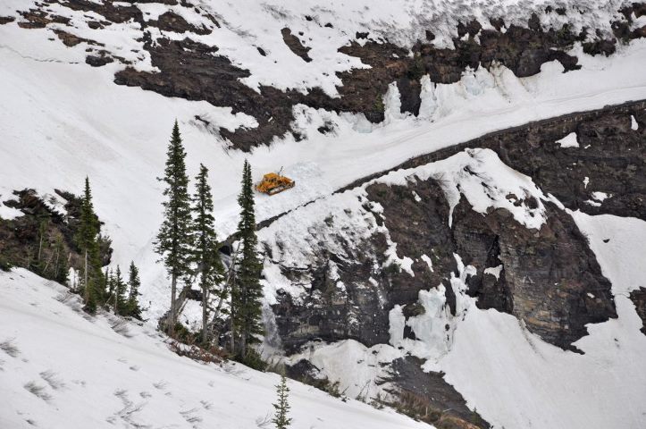
Snow Crews Making Progress on the Going-to-the-Sun Road
Plows continue to make progress on snow removal throughout Glacier National Park. The latest update on the Glacier website reports that the West Lakes Road Crew has cleared snow down to the pavement up to Swede Point - roughly 1.5 miles above The Loop.
On the west side of the Divide the Going-to-the-Sun Road is open from the West Entrance to the Lake McDonald Lodge. On the east side the road to open to Rising Sun.
The update also mentions that the Hudson Bay Road Crew removed snow from the Two Medicine Campground, and has encountered snow drifts that were 5 to 20 feet deep in the campground loops. Right now the Two Medicine Road is open to Running Eagle Falls.
For a complete update, please click here.
The photo below was taken near Crystal Point on Wednesday:

To view all of the latest snow clearing photos, visit the Glacier Photo Page on Flickr.
Jeff
Hiking in Glacier.com
National Natural Landmark Photo Contest for 2012 Opens
Don’t forget your camera as you head outdoors this spring: the National Natural Landmarks Program annual photo contest is now open and accepting entries.
“We’re looking for images that capture the beauty and diversity of these natural areas” said National Park Service Director Jonathan B. Jarvis.
Winning photographs will be featured in the 2013 National Natural Landmarks calendar. Contest entries will be accepted through June 30, and each photographer can submit up to three entries. Winners will be announced in September. There are no restrictions on the date of a photograph; however, please remember that “old” slides and prints often lose their quality over time.
Each photograph must be from a different national natural landmark. Images of the 13 sites featured in the 2012 calendar will not be accepted. Those winning photos can be viewed here.
For full contest information and submission requirements for the ninth annual contest, please click here.
There are nearly 600 national natural landmarks nationwide representing an array of natural features. National natural landmarks include features on private, state, municipal, and federal lands. Program participation is voluntary and not all landmark sites are open to the public.
National natural landmarks are designated by the Secretary of the Interior following rigorous scientific study. The National Natural Landmarks Program is managed by the National Park Service and recognizes significant examples of biological and geological features and supports the cooperative conservation of these important examples of America’s natural heritage.
Further information about the National Natural Landmarks Program, including a complete list of designated sites and their accessibility is available at www.nature.nps.gov/nnl/.
Jeff
Hiking in Glacier.com
Thursday, April 19, 2012
The Great Glacier Giveaway
Glacier Country Montana is giving you a chance right now to win a five-day, four-night vacation getaway to Western Montana’s Glacier Country.
 The lucky winner will receive a trip for two to the heart of Glacier Country with destinations that include Whitefish and Glacier National Park. The prize package includes airfare (up to $600), double occupancy accommodations, a rental car, red bus tour for two, trail ride for two, zip line adventure for two, raft trip for two, guided hike for two, whiskey tasting for two (must be at least 21 years old) and a gas card (approximate retail value: $3,000).
To enter, simply visit the Glacier Country website and sign-up by April 31st.
By the way, some of the partners in this promotional giveaway include the Glacier Raft Company and Glacier Guides, two of our advertisers on our Thing To Do page.
Jeff
Hiking in Glacier.com
Wednesday, April 18, 2012
Book your Montana State Parks campsite online
Montana State Parks is reminding the public that they can book campsite reservations for the 2012 summer season online at stateparks.mt.gov or by phone at 1-855-922-6768.
Start dates for reservations booked online or by phone are for the peak season which starts Friday, May 25 of Memorial Day weekend.
 Twenty of Montana’s State Parks are available through the campsite reservation program with 12 of the 20 parks featuring electric hookups. There are more than 500 sites in total to reserve, including several yurts, cabins and tipis.
Montana State Parks reservation campsites: Bannack, Beavertail Hill, Big Arm, Black Sandy, Brush Lake, Cooney, Finley Point, Hell Creek, Lake Mary Ronan, Lewis & Clark Caverns, Logan, Makoshika, Missouri Headwaters, Placid Lake, Salmon Lake, Thompson Falls, Tongue River Reservoir, Wayfarers, West Shore, and Whitefish Lake.
Basic campsite costs: $15 dollars per night for residents and $23 dollars per night for non-residents during peak spring/summer season. To reserve a campsite online or by phone is $10. Montana seniors and residents with disabilities are to phone the call center for accommodations and special rates.
Spontaneous campers are not left out as each park holds back approximately 25% of their campsites outside of the reservation program, for traditional first-come, first served camping visits, which are available starting May 1.
To make a reservation, visit: stateparks.mt.gov.
The campsite reservation program launched in March of 2011 and saw more than 7,500 campers making their reservations through the new program during the 2011 spring/summer season (March – September).
Jeff
Hiking in Glacier.com
Spring Wildlife Migration Fully Underway in Grand Teton National Park
One of the characteristic signs of spring happens to be the annual migration of large animals from their winter range. With the arrival of warmer weather and the resulting snow melt, elk and bison are now migrating from the National Elk Refuge toward their traditional summer ranges in Grand Teton National Park and surrounding national forests. Consequently, motorists should be alert for wildlife on the move and drive with extra caution during the coming weeks.
 Herds of elk and bison are again crossing park roads, especially Highway 26/89/191, and wandering near roadsides. They often move during low light conditions and generally are most active between dusk and dawn. Moose can be found browsing in both the sagebrush flats and riparian areas such as the Gros Ventre River and Buffalo Fork of the Snake River just south of Moran Junction. Mule deer, wolves, bears and other animals may also be encountered on or near park roads, and pronghorn antelope will soon make their way back to Jackson Hole.
Animals are typically weakened from the rigors of a Jackson Hole winter and may be forced to use precious energy when startled or disturbed by the presence of vehicles and humans on foot or bicycle. Visitors and local residents should keep their distance from all wildlife, maintaining a distance of 100 yards from bears or wolves and 25 yards from other wildlife, including nesting birds. Public closures are now in effect near sage grouse leks throughout the park. Those who visit these areas must obey the posted closures to reduce disturbance to sage grouse using their traditional mating arenas. Wildlife protection closures will be in place for the next 4-6 weeks while birds are present.
Motorists are advised to drive the posted speed limit and be prepared to stop suddenly when animals cross the road unexpectedly. Driving slower than indicated speed limits, especially at night, can increase the margin of safety. Collisions between motor vehicles and wildlife may result in severe damage to the vehicle, serious or fatal injuries to occupants of that vehicle, and/or death for the animal involved.
Although it may be a cliché, spring migration is a critical time to give wildlife a brake!
Jeff
Hiking in Glacier.com
Tuesday, April 17, 2012
The Best Waterfall Hikes in Glacier National Park
Glacier National Park has more than 200 waterfalls scattered throughout the park. So, with only a limited amount of vacation time, which falls should you visit on a day hike? Below are my top waterfall hikes that will hopefully lend some guidance.
 Virginia Falls – Dropping more than 50 feet off a sheer cliff face, Virginia Falls just might be one of the most beautiful falls I’ve ever seen. Additionally, waterfall aficionados will get a chance to see St. Mary Falls, and two other very impressive, but unnamed falls along the way as well.
St. Mary Falls – If you’re looking for a very short hike to see an awesome waterfall, this should fit the bill.
Redrock Falls – An outstanding choice for an easy hike. In addition to a very impressive series of cascades and falls, you’ll also visit two picturesque sub-alpine lakes, and maybe even have a chance to see a moose along the way.
Running Eagle Falls – “Trick Falls” is a must see in the Two Medicine Area. It’s a very easy, handicap accessible trail.
Florence Falls – I would have to rank this as the second most impressive waterfall that can be reached on a day hike in Glacier. The reason it ranks 5th on this list is a result of the distance you have to walk to reach it. Additionally, the trail stays within the confines of the forest for most of its length. Having said that though, there is a point on the trail, at Mirror Pond, that just might be one of the most scenic spots in the entire park.
 Johns Lake Loop – An easy loop hike off the Going-to-the-Sun Road that visits Sacred Dancing Cascade and McDonald Falls.
Apikuni Falls – Beautiful falls in a small box canyon in the Many Glacier area.
Rockwell Falls – The trail travels through several open meadows in the Two Medicine valley. You’ll also have a good chance of seeing a moose along the way.
Baring Falls – Very easy hike off the Going-to-the-Sun Road on the eastern side of the park.
Ptarmigan Falls – This is one of the more impressive falls in the park. However, steep terrain around the falls makes it virtually impossible to get a close-up view. Moreover, trees block a full view of the falls from top to bottom. This waterfall, however, makes my top 10 list because the hike offers outstanding views of the Many Glacier Valley for most of its length.
Jeff
Hiking in Glacier.com
Monday, April 16, 2012
Experience National Park Week at Grand Teton National Park
Grand Teton National Park offers free admission and more during National Park Week from April 21-29. Several fun-filled activities and events are planned for the whole family and these are also free of charge. Visitors and local residents are encouraged to plan a getaway to experience the natural wonder of Grand Teton during National Park Week. As this year's theme "Picture Yourself in a Park" suggests, it's a perfect time to make memories and capture photographs to share online at http://www.nps.gov/npweek/.
To celebrate National Park Week and the arrival of spring, ranger naturalists will lead early-morning tours to observe strutting sage grouse as they perform their annual courtship dance on an historic lek (mating arena) located just off the Antelope Flats Road near Mormon Row. Tours will take place April 21-22 and April 28-29 and begin from the Craig Thomas Discovery and Visitor Center at 5:30 a.m. Reservations are required; call 307.739.3399 to make a reservation and get advice on what to wear and bring along.
The Teton Park Road is free of snow, but vehicles are not allowed to drive it until May 1st. Consequently, National Park Week presents an wonderful opportunity to enjoy a hike, bike ride or rollerblade outing on the road before summer traffic begins. Spring weather can be changeable and inclement, so be prepared with layered clothing and/or a windproof jacket, and carry water and energy snacks.
In recognition of National Park Week, The Murie Center staff will offer guided tours of the historic Murie Ranch at 4 p.m. on Saturday April 21 and Saturday April 28. Explore the Teton home of the Murie family that served as a base camp and center for the American conservation movement in the 1950s and 60s.
Several activities are scheduled for National Junior Ranger Day on Saturday, April 28 at the Craig Thomas Discovery and Visitor Center in Moose. Festivities include:
•10 a.m. -a living history demonstration on mountain men
•11 a.m. to 2 p.m. - an inspection of vehicles and equipment regularly used in park operations; these will include an ambulance, fire engine, patrol car and snowplow
•11 a.m. to 12:30 p.m. - a live bird demonstration by Teton Raptor Center bird biologists
•11 a.m. to 2 p.m. - a ranger boot camp and obstacle course where children compete in physical activities that mimic park ranger jobs; an animal Olympics game where youngsters can test their skills against the abilities of various wildlife species; a story corner for listening to tales about Grand Teton; a touch table with animal furs, feathers and bones to feel; a cultural history station that showcases objects from the David T. Vernon Collection of Indian Arts; and a station where children can dress up in an genuine ranger uniform.
•2 p.m. - a second mountain man demonstration.
Children who participate in at least three of the activities will earn either a Junior Ranger patch or badge. Grand Teton Association will offer a 15-percent discount in the Discovery Center bookstore on Junior Ranger Day. Numerous educational and informational books and other interesting items (videos, posters, ornaments, plush animals, toys, etc.) may be purchased using the special Junior Ranger Day discount.
During National Park Week, all 397 national park areas offer free admission all week long. A seven-day pass to Yellowstone and Grand Teton national parks is normally $25 for a private vehicle.
Jeff
Hiking in Glacier.com
Sunday, April 15, 2012
The Mountain
The Mountain is another excellent video from Terje Sorgjerd. The Norwegian filmed the video on and around Spain's tallest mountain, El Teide. There are several very interesting timelapse clips on here:
Jeff
Hiking in Glacier.com
Terje Sorgjerd The Mountain from Amsterdam on Vimeo.
Jeff
Hiking in Glacier.com
Saturday, April 14, 2012
Volunteers needed in "The Bob"
The Bob Marshall Wilderness Foundation just published their project list for the 2012 season earlier this week. Projects are scheduled from early June through mid-September, and include several multi-day projects such as the South Fork Flathead River Float, which includes two days of hiking just to reach the put-in where volunteers will help to remove weeds on the class II-III designated Wild & Scenic River.
Participating in a Bob Marshall Wilderness Foundation volunteer project will allow you to explore this vast and remote area south of Glacier National Park, meet new people, learn new trail and backcountry skills, as well as provide the needed work to help keep trails in the Bob Marshall Wilderness Complex open and campsites pristine.
This is a great way to explore the beautiful backcountry wilderness of Montana, or to give something back to "The Bob".
For more information, please click here.
Jeff
Hiking in Glacier.com
Friday, April 13, 2012
Video: Weather in Grand Teton
A couple weeks ago I posted a video called Day and Night in Grand Teton, the first of four videos in a new series called, From Valley to Peak. The videos are being produced by Jackson-based videographers Jesse Ryan and Ryan Christopher of New Thought Media on behalf of Grand Teton National Park Foundation and Grand Teton Association. Below is the second installment in this excellent series called, Weather in Grand Teton:
Jeff
Hiking in Glacier.com
Jeff
Hiking in Glacier.com
Thursday, April 12, 2012
Biologists to Begin Grizzly Bear Capturing for Research and Management
As part of an Interagency Program to monitor the population of grizzly bears in the Northern Continental Divide Ecosystem (NCDE), Montana Fish, Wildlife & Parks, the US Fish & Wildlife Service, the National Park Service, and Tribal wildlife managers are working to inform the public that pre-baiting and scientific capture operations are once again about to begin in parts of western Montana.
 Biologists will begin to work in their respective jurisdictions this month. Throughout the summer months, biologist will work in the Blackfoot Valley, along the Rocky Mountain Front, in the Swan and Clearwater River Valleys, within Glacier National Park, and in the North and Middle Forks of the Flathead River. Capturing will continue intermittently through the end of October. Traps will also be set periodically on private and public lands where bear/human conflicts are occurring.
All areas where work is being conducted will have warning signs posted along the major access points to the trapping site. It is critical that all members of the public heed these signs.
Monitoring of grizzly bear distribution and population trend are vital to ongoing recovery of grizzlies in the NCDE. In order to attract bears, biologists utilize natural food sources such as fresh road–killed deer and elk. Potential trapping sites are baited with these natural foods and if indications are that grizzly bears are in the area, snares or culvert traps will be used to capture the bears. Once captured, the bears are sedated, studied, and released in accordance with strict protocols.
For more information regarding grizzly bear trapping efforts call FWP in Missoula at 406-542-5500, FWP in Kalispell at 406-752-5501, and the FWP Bear Management Office in Choteau at 406-466-5100. Officials in Glacier Park can be contacted at 406-888-7800, on the Blackfeet Reservation at 406-338-7207, or on the Confederated Salish and Kootenai Reservation at 406-883-2888
Jeff
Hiking in Glacier.com
Proper Use of Bear Spray
While hiking in Glacier National Park, or any wilderness area that has grizzly bears, your best line of defense in the unlikely event of an attack is bear spray. According to one study, bear spray is 95% effective in stopping bear attacks, while firearms are only 55% effective.
Below is a demonstration on how to properly use bear spray by Carnivore Specialist, Nathan Webb. The video was produced in conjunction with the BearSmart program sponsored by the Sustainable Resource Development Department in Alberta, Canada.
In a January 2012 Backpacker Magazine article, Dave Parker, a certified bear spray safety trainer, is quoted as saying that:
"If an animal comes within 50 feet, use your spray. If the bear isn’t running, point the nozzle about 30 feet away, and fire a series of one-to-two-second bursts. If it’s charging, point the spray at the bear’s chest and hold the trigger until the can is fully discharged. Out of spray and the grizzly is still charging? Don’t run, lay on your stomach, cover your head, and play dead."
Jamie Jonkel, a bear management specialist with the Montana Fish, Wildlife & Parks, offers some additional advice:
"If a bear charges from a distance, spray a two to three second burst in the direction of the bear. Experts recommend bear spray with a minimum spray distance of 25 feet.
Point the canister slightly down and spray with a slight side-to-side motion. This distributes an expanding cloud of spray that the bear must pass through before it gets close to you. Spray additional bursts if the bear continues toward you.
Sometimes just the noise of the spray and the appearance of the spray cloud is enough to deter a bear from continuing its charge. Spray additional bursts if the bear makes additional charges.
If you have a sudden close encounter with a bear, spray at the front of the bear. Continue spraying until the bear either breaks off its charge or is going to make contact."
For more information on hiking in bear country, including how to avoid a surprise encounter, please click here.
If you need to purchase bear spray for an upcoming hiking trip, please click here.
Jeff
Hiking in Glacier.com
Wednesday, April 11, 2012
Apgar Transit Center Parking Lot Expansion Proposal
Glacier National Park is hoping to accommodate visitors on the west side of the park by adding more parking. Last week park officials released an environmental study focused on expanding the parking lot at the Apgar Transit Center.
As a preliminary step toward implementing the decision in the Final General Management Plan to replace the interim visitor center in Apgar Village with a visitor center and museum north of the Going-to the-Sun Road and Camas T-intersection, the park plans to relocate visitor center operations from Apgar Village to the Apgar Transit Center in the near future. The transit center parking lot was designed to provide parking for visitors using the transit system, and is too small to accommodate additional parking once visitor center operations are moved.
The environmental assessment evaluates two alternatives: a no action alternative, and an action alternative. The no action alternative describes the current condition if the transit center parking lot was not expanded, and the action alternative (preferred alternative) addresses the proposed expansion of the existing parking lot.
Under the preferred alternative, the existing parking lot at the Apgar Transit Center would be expanded. The existing lot contains 132 passenger car spaces (including 5 accessible spaces) and 15 RV or oversized vehicle spaces. The parking lot would be extended approximately 90 feet to the north and 90 feet to the east. The northern expansion would accommodate approximately 60 passenger cars, including 4 accessible spaces, and the eastern expansion would provide parking for approximately 6 RV’s and oversized vehicles. With some possible minor changes to the number of existing spaces, the expanded parking lot would provide approximately 190-195 spaces for passenger vehicles, including 9 accessible spaces, and 21 RV or oversized vehicle spaces.
Construction is anticipated to occur during fall and the following spring. The project is estimated to take approximately 8 weeks to complete. Cost to complete the project is estimated at $500,000, which would be funded by the Federal Lands Highway Program.
You can leave a comment on the proposal by visiting the project's website. All comments are due by May 7th.
Jeff
Hiking in Glacier.com
Injured Skier Rescued From Granite Canyon
NPS Digest is reporting that a 31-year-old backcountry skier was rescued from Granite Canyon in Grand Teton National Park in a multi-agency effort last Saturday. Josh Tatman of Jackson, Wyoming, sustained injuries after falling about 300 feet from the top of Endless Couloir just outside the boundary of the Jackson Hole Mountain Resort.
Tatman was skiing alone when he took what was described as a slow twisting fall. He called Jackson Hole Mountain Resort ski patrol on his cell phone and reported that he was injured and needed help. Rangers were flown to a landing zone in Granite Canyon, where they waited for ski patrol members to lower Tatman to them. Tatman was initially lowered by patrollers skiing a rescue toboggan down, but due to snow conditions and the terrain had to set up a rope belay system and lowered him in six 300-foot segments into the canyon. He was then taken to St. John’s Medical Center for treatment.
Endless Couloir is on a north facing slope in Granite Canyon and runs almost 3,000 vertical feet on a roughly 40 degree slope. It is unusual for individuals to have cell phone service in that area of Granite Canyon. Tatman did have an avalanche beacon with him but it was in his backpack. Best practice is for individuals to wear avalanche beacons on their person in case they get caught in an avalanche when gear and outer layers of clothing can easily be torn off from the force of the avalanche.
The avalanche danger was listed as low below 9,000 feet and moderate for high elevations on Saturday by the Bridge-Teton Avalanche Center.
Jeff
Hiking in Glacier.com
Tuesday, April 10, 2012
The Best Easy Hikes in Glacier National Park
While creating my list of the Top 10 Hikes in Glacier National Park, I realized that many of the trails that made the list were fairly long day hikes, which obviously won't appeal to everyone. So I decided to start from scratch and build a new list, based on the best of the easier hikes in the park. Hopefully you'll find this helpful as a starting point in trying to decide where to hike during your visit.
 Hidden Lake Overlook – This extremely popular hike, starting from Logan Pass, visits the Hidden Lake Overlook where you’ll have outstanding panoramic views into the heart of Glacier.
Redrock Falls - An outstanding choice for an easy hike. In addition to the very impressive series of cascades and falls, you’ll also visit two picturesque sub-alpine lakes, and maybe even have a chance to see a moose along the way.
Virginia Falls - Dropping more than 50 feet off a sheer cliff face, Virginia Falls just might be one of the most beautiful falls I’ve ever seen. Additionally, waterfall aficionados will get a chance to see St. Mary Falls, and two other very impressive, but unnamed falls along the way.
Swiftcurrent Nature Trail – Take an easy stroll around Swiftcurrent Lake for some outstanding views of the Many Glacier Valley. As a bonus, hikers may even see a bear or a moose along the way.
Johns Lake Loop - Easy loop hike that visits a small woodland pond, Sacred Dancing Cascade, and McDonald Falls.
St. Mary Falls - If you’re looking for a very short hike to see an awesome waterfall, this should fit the bill.
 Rocky Point - Stunning views of Lake McDonald, as well as the mountains in the Sperry Glacier vicinity.
Running Eagle Falls - “Trick Falls” is a must see in the Two Medicine Area. It’s a very easy, handicap accessible trail.
Forest and Fire Nature Trail – A great hike if you’re looking to get away from the crowds. Witness the re-growth of a brand new forest as it recovers from the 2001 Moose Fire.
Trail of the Cedars – This popular loop hike travels along a raised boardwalk as it passes though a forest of ancient western hemlocks and red cedars. You’ll also have outstanding views of the stunning Avalanche Gorge.
Any other hikes you think I should've included on this list?
Jeff
Hiking in Glacier.com
Monday, April 9, 2012
Trail Improvement Projects in the Bob Marshall Wilderness Complex
The Spotted Bear Ranger District is lining up a full slate of trail projects in partnership with the Montana Conservation Corps (MCC). The funding for this work comes from a mix of Forest Service funds matched with county Resource Advisory Committee (RAC) grants, along with the collaborative partnerships with the Flathead Chapter of the Backcountry Horsemen and the MCC. Significant improvements are targeted for:
* Trilobite Ridge Trail no. 241
* Bruce Mt. – Chipmunk Peak no. 99
* Flathead Divide/Twin Peaks no. 200
* Jenny Creek no. 141
* Rapid Creek no. 139
Details on these projects are explained in the Bob Marshall Wilderness Complex 2012 Newsletter.
Jeff
Hiking in Glacier.com
* Trilobite Ridge Trail no. 241
* Bruce Mt. – Chipmunk Peak no. 99
* Flathead Divide/Twin Peaks no. 200
* Jenny Creek no. 141
* Rapid Creek no. 139
Details on these projects are explained in the Bob Marshall Wilderness Complex 2012 Newsletter.
Jeff
Hiking in Glacier.com
Sunday, April 8, 2012
America's Wilderness
Simply beautiful! A National Park Service salute to the 1964 Wilderness Act:

Jeff
Hiking in Glacier.com
Jeff
Hiking in Glacier.com
Saturday, April 7, 2012
Thru-hiking: What does it really take?
Everyone has seen videos and photos of hikers trekking on one the three great long-distance trails: the Appalachian Trail, Pacific Crest Trail or Continental Divide Trail. Most of those images highlight the incredible beauty of the trails. But what is it really like to thru-hike a long-distance trail? What does it really take?
Here's a video from Brett, Nate, and Tyler as they discuss their thru-hike of the Pacific Crest Trail. Most importantly, these guys are mere mortals, not uber adventurers like Andrew Skurka, or even Bear Grylls. Prior to their hike, none had a great deal of experience with backpacking. So, from this perspective, they provide their thoughts on what it's really like to thru-hike a long distance trail. This video was produced for The Clymb a few weeks back:
Jeff
Hiking in Glacier.com
Friday, April 6, 2012
US Forest Service targets $40.6M to purchase, restore lands in 15 states
Agriculture Secretary Tom Vilsack today announced the U.S. Forest Service will dedicate $40.6 million for 27 exceptional land acquisition projects in 15 states that will help safeguard clean water, provide recreational access, preserve wildlife habitat, enhance scenic vistas and protect historic and wilderness areas.
Projects funded are in Alaska, California, Colorado, Georgia, Idaho, Indiana, Michigan, Missouri, Montana, New Mexico, North Carolina, Oregon, Tennessee, Utah and Washington. Projects range from protecting nationally significant lands from threat of residential development in North Carolina to help pave the way to help purchase the largest single parcel of privately held land with the Kootznoowoo Wilderness on the Tongass National Forest in Alaska.
The money is made available through the Land and Water Conservation Fund, created by Congress in 1964 to provide funding to federal, state and local governments to purchase land, water and wetlands. The fund receives the majority of its money through royalty payments from offshore oil and gas revenues to mitigate the environmental impacts of those activities. Those funds also are augmented by additional money or in-kind services of a variety of partnerships.
Lands are purchased from willing sellers at fair-market value or through partial or outright donations of property. Landowners may also sell or donate easements on their property that restrict commercial development while keeping the land in private ownership.
Two projects were approved for the state of Montana:
• $2 million has been appropriated towards the Legacy Completion in the Lolo and Flathead National Forests: The project will enhance resource management within and adjacent to the Crown of the Continent by protecting healthy watersheds, diverse habitats for threatened and endangered species, and open space on a landscape-scale and public access to high quality recreation opportunities. This parcel is a part of the Montana Legacy project, one of the most ambitious conservation projects in modern Forest Service history and includes a 111,740 acre donation from conservation partners.
• $2 million was also appropriated towards the Tenderfoot (Part I) watershed project in the Lewis and Clark National Forest: The Tenderfoot watershed in Central Montana is remarkably diverse spanning areas from 3,200 feet elevations sub-alpine mountains to grass meadows and riparian areas. The acquisition parcels will provide high quality water and fisheries habitat for west slope cutthroat trout, and habitat for elk, moose, deer and many other wildlife species. The land offers incredible scenic views and extraordinary recreation opportunities, especially for anglers and hunters.
To see all of the projects approved for funding in 2012, please click here.
Jeff
Hiking in Glacier.com
Flathead River User Survey
The recently published Bob Marshall Wilderness Complex 2012 Newsletter is reporting that the Flathead National Forest will be conducting a River User Survey on all three forks of the Flathead River this summer.
The survey is designed to gather information from all river users, including rafting, stock, hiking, and fishing parties – essentially anyone who is recreating in the river corridor may be asked to take the survey. The survey will ask a series of questions about what the river user experienced on the trip that they are currently on, or just finished. Forest Service employees will staff key locations to intercept river users and will ask people to participate. Survey participants can choose to complete the survey on location, or take a copy and complete it at the end of their trip, and mail in afterwards.
The Forest Service hopes to reach all types of river recreationists including outfitted and guided clients. Data gathered from the survey will be compiled and used to help river managers better understand the perceptions of river users in the wilderness. The results of the survey data may be used in future wilderness and river planning efforts. If you're asked to participate in the survey, the Forest Service hopes you are able to take the time to share your information about your wilderness river experience.
Jeff
Hiking in Glacier.com
Thursday, April 5, 2012
Old Faithful Cabin Repurposing and Dormitory Construction Plan Approved
A plan to return 67 cabin units that are presently used for concessioner employee housing in the Old Faithful Lodge Area to visitor use and construct a new dormitory in the Old Faithful Administrative Area has been approved.
A Finding of No Significant Impact (FONSI) allowing repurposing the cabins to provide an increased number of affordable visitor lodging units at Old Faithful and construction of a new employee dormitory for displaced employees was signed by the National Park Service Intermountain Region Director on April 2, 2012. An Environmental Assessment (EA) that analyzed three alternatives was released for public review and comment in January 2012.
Among the highlights of the approved preferred alternative:
• Provide for additional affordable lodging options in Yellowstone National Park.
• Rehabilitating the interior of the cabin units would include new floor coverings, wall coverings, electrical systems, bathroom fixtures, and gas heaters. A portion of the cabins would be made accessible.
• Enhancing safety and improving accessibility of pathways to the cabin area. Many of the asphalt walkways within the cabin area are old and deteriorating with numerous rough spots, uneven surfaces, raveling edges, and missing pavement. These walkways would be replaced or repaired as part of this project.
• Construction of an employee dormitory in the Old Faithful administrative area for employees displaced from the repurposed cabin units.
The project will proceed when funding becomes available, with the cost of the project to be determined when detailed designs are completed.
Copies of the EA and the FONSI are available on the National Park Service Planning, Environment and Public Comment (PEPC) Web site at http://parkplanning.nps.gov/yell.
Jeff
Hiking in Glacier.com
Wednesday, April 4, 2012
Glacier National Park snow plowing begins
More signs of spring: Glacier National Park announced yesterday that snow plowing has begun at a couple of locations around the park.
 On April 2nd the West Lakes Road Crew removed snow from the Fish Creek Campground and Picnic areas, encountering snow depths of 6 – 24 inches. The Camas and Fish Creek roads are covered with 1 to 4 inches of ice. They also started removing snow from the Going-to-the-Sun Road between Lake McDonald Lodge and Avalanche Creek. Snow depths were 12 – 26 inches. The road surface was covered with 2 to 6 inches of ice.
The Hudson Bay Road Crew started plowing the Many Glacier Road from the dam into the valley. They encountered snow drifts of up to 10 feet. The weather was stormy, windy and cold.
For the most up-to-date information on the progress of the plows, please click here.
Jeff
Hiking in Glacier.com
State Land and Water Conservation Fund Creates or Enhances Nearly 200 Parks across Country in 2011
Last week the National Park Service announced that revenue from leases for offshore oil and gas development in federal waters helped states build or improve 198 parks across the country in 2011, ranging from establishing a new park on Texas’ most pristine river, to protecting and providing public access to prehistoric petroglyphs in Wyoming to building a new wheelchair-accessible playground in Indiana, according to a new report issued by the Interior Department’s National Park Service.
Under the Land and Water Conservation Fund State and Local Assistance Program, the Park Service awarded $33.3 million in grants to states to help communities invest in new parks or renovate or expand existing parks. States, local communities, and other partners exceeded the required dollar-for-dollar match by providing $43.9 million to complete the projects.
“The Land and Water Conservation Fund State and Local Assistance Program powers a federal-state partnership that benefits communities and strengthens our economy,” said National Park Service Director Jonathan B. Jarvis. “Thanks to these grants, we are connecting Americans with the great outdoors by providing quality recreational opportunities that are close to home, open to the public, and accessible to all.”
Through the fund, a portion of the revenue derived from oil development of federal lands is shared with local communities to provide recreational opportunities for the public. The grants must be matched by partners at least a dollar-for-dollar. To review some of the projects that received funds, please click here.

Jeff
Hiking in Glacier.com
Under the Land and Water Conservation Fund State and Local Assistance Program, the Park Service awarded $33.3 million in grants to states to help communities invest in new parks or renovate or expand existing parks. States, local communities, and other partners exceeded the required dollar-for-dollar match by providing $43.9 million to complete the projects.
“The Land and Water Conservation Fund State and Local Assistance Program powers a federal-state partnership that benefits communities and strengthens our economy,” said National Park Service Director Jonathan B. Jarvis. “Thanks to these grants, we are connecting Americans with the great outdoors by providing quality recreational opportunities that are close to home, open to the public, and accessible to all.”
Through the fund, a portion of the revenue derived from oil development of federal lands is shared with local communities to provide recreational opportunities for the public. The grants must be matched by partners at least a dollar-for-dollar. To review some of the projects that received funds, please click here.
Jeff
Hiking in Glacier.com
Tuesday, April 3, 2012
Annual Bob Marshall Wilderness Complex Public Meeting
The public is invited to the annual Bob Marshall Wilderness Complex (BMWC) Public Meeting on April 14, 2012, at the Seeley Lake Community Hall in Seeley Lake, Montana. The Community Hall is located just north of the town of Seeley Lake on the east side of Montana Highway 83 near mile marker 15.
“This year is the twenty-fifth year that we will be collecting monitoring-data based on public participation and partnerships in managing the Bob Marshall Wilderness Complex and the wilderness plan,” said Deb Mucklow, BMWC Lead District Ranger.
The BMWC is comprised of the Bob Marshall Wilderness, Great Bear Wilderness, and Scapegoat Wilderness. Together they comprise an area of more than 1.5 million acres. This is the third largest wilderness complex in the lower 48 states. The complex is managed by four national forests (Flathead, Lolo, Helena, and Lewis & Clark) and five ranger districts (Spotted Bear, Hungry Horse, Seeley Lake, Lincoln, and Rocky Mountain.)
Recently the Forest managers and Fish and Wildlife staff prepared the annual BMWC newsletter. The newsletter is available on the Flathead National Forest web page under Special Places (http://www.fs.usda.gov/attmain/flathead/specialplaces). This newsletter gives background and highlights of information that will be shared at the public meeting.
For additional information, please contact the Spotted Bear Ranger District at (406) 387-3800.
Jeff
Hiking in Glacier.com
The Top 10 Hikes in Glacier National Park
Many people who are unfamiliar, or are making their very first visit to Glacier National Park, want to know what the best day hikes are in the park. Below are my personal top ten hikes in Glacier. Hopefully this will be a helpful starting point as you try to decide where you want to hike during your visit.
 Highline Loop – This world famous hike should be on the bucket list of any self respecting hiker. The incredible views, the wildlife and the wildflowers, all combine to make this a hike you'll remember the rest of your life.
Piegan Pass – Just a notch below the Highline Trail on the“awesome meter”, but far less crowded.
Ptarmigan Tunnel – If you’re anywhere near Many Glacier, the hike to Ptarmigan Tunnel shouldn’t be passed up. The highlight of the hike is passing through a 240-foot tunnel that cuts a hole through the Ptarmigan Wall. It was built for horses and early park tours by the Civilian Conservation Corp in the 1930's. After hiking all day in the Many Glacier Valley, walking to the other side of the tunnel is like walking into another world.
Grinnell Glacier - Another extremely popular hike in the Many Glacier area. This one visits the famous 300-acre glacier that sits just below the Continental Divide.
Preston Park - One of my favorite areas in Glacier is Preston Park. It’s a large, incredibly beautiful alpine meadow, located in the valley between Mt. Siyeh and Matahpi Peak (near Logan Pass).
Iceberg Lake - One of the most popular hikes in Glacier. And for good reason. This is a great opportunity to see icebergs floating in a gorgeous alpine lake. You’ll also have commanding views of the Ptarmigan Wall, an arête, or thin ridge of rock separating two valleys that have been carved by glaciers.
Cracker Lake - Cracker Lake in the Many Glacier area has to be one of the most beautiful lakes in the world. The lake has the most magnificent turquoise color you’ll ever see. If you could ignore the magnificent scenery of the surrounding mountains, it would still be well worth the hike just to see the amazing color of the lake. If it weren’t for the walk through a long section of forest, I would’ve ranked this one a little higher.
 Pitamakan Pass - Dawson Pass usually gets all the attention in Two Medicine. However, at least for me, I think the views from Pitamakan Pass are much more dramatic. From the knife-edge pass you can see five lakes on either side of you.
Scenic Point - The rock outcropping that sits above alpine tundra meadows offers stunning panoramic views of the Two Medicine Valley. On a clear day you can even see the Sweet Grass Hills rising above the Great Plains 90 miles away!
Dawson Pass - One of the most popular backcountry hikes in the Two Medicine area is the one up to Dawson Pass. The hike can be shortened to just 9.4 miles by taking the shuttle boat across Two Medicine Lake.
So did I miss anything? Are there any other hikes that you think I should've included on this list?
Jeff
Hiking in Glacier.com
Monday, April 2, 2012
NPS Establishes National SAR Academy
The National Park Service has founded a National Search and Rescue Academy (NSARA) to provide comprehensive, standardized Servicewide training in basic search and rescue competencies.
NSARA will be based in Northern Arizona in order to take advantage of the challenging rescue environments available throughout the region. The first training offering, which will be a six-week-long course in California, will be this fall (see the Friday training calendar for particulars).
NSARA will offer a highly structured learning environment. Participants will have to be physically fit and will begin each training day with fitness training and an intensive safety briefing. Training will occur in the classroom setting as well as in various physically challenging technical outdoor environments. Personal preparedness, rescuer safety, and operational leadership principles will be emphasized throughout.
NSARA will provide participants with a venue to efficiently attain field rescuer skills in a single condensed format that would typically require numerous years to obtain, including essential field rescue skills in ground search operations, the incident command system, swiftwater rescue, technical rope rescue, search management, and basic aviation safety.
NSARA will directly lead to improved workplace safety for employees and enhanced SAR response capability for the agency. National Park Service visitors and employees will both directly benefit from this program.

Jeff
Hiking in Glacier.com
NSARA will be based in Northern Arizona in order to take advantage of the challenging rescue environments available throughout the region. The first training offering, which will be a six-week-long course in California, will be this fall (see the Friday training calendar for particulars).
NSARA will offer a highly structured learning environment. Participants will have to be physically fit and will begin each training day with fitness training and an intensive safety briefing. Training will occur in the classroom setting as well as in various physically challenging technical outdoor environments. Personal preparedness, rescuer safety, and operational leadership principles will be emphasized throughout.
NSARA will provide participants with a venue to efficiently attain field rescuer skills in a single condensed format that would typically require numerous years to obtain, including essential field rescue skills in ground search operations, the incident command system, swiftwater rescue, technical rope rescue, search management, and basic aviation safety.
NSARA will directly lead to improved workplace safety for employees and enhanced SAR response capability for the agency. National Park Service visitors and employees will both directly benefit from this program.
Jeff
Hiking in Glacier.com
Sunday, April 1, 2012
Jenny Lake Trail Restoration Project
Trail conditions in the Grand Tetons have declined dramatically over the past twenty years, and will soon reach a critical state. In an effort to reverse this trend, the Grand Teton National Park Foundation will launch a large-scale restoration program this year that will initially focus on the Jenny Lake Trail. This project will extend from the parking lot, around the lake, and include the spurs that lead to Hidden Falls and Inspiration Point.
 The Jenny Lake restoration project will be the park's signature project that honors the National Park Service's 100th anniversary in 2016, and will launch a wider-spread effort that will upgrade Grand Teton's most prominent trails and provide for their long-term care. Jenny Lake is the park's most traveled route, but receives a limited amount of maintenance each year. Massive erosion and denuded soils have created a dangerous experience for visitors that has resulted in many injuries each summer, and a degradation of natural resources.
Here are some of the Jenny Lake Trail restoration highlights:
• Rebuild over 9 miles of trail and create trail sustainability
• Replace 4 aging bridges and replace/create multiple stone retaining walls
• Incorporate numerous interpretive wayside exhibits
• Rehabilitate thousands of square feet of denuded landscape
• Create a sustainable, low-impact viewing area for Hidden Falls
• Redesign the confusing Jenny Lake complex to provide clear access to the sights
The hike into Cascade Canyon from Jenny Lake is truly one of the great hikes in our National Park System. If you would like to help the Grand Teton National Park Foundation, please visit their website by clicking here.
Jeff
Hiking in Glacier.com
Subscribe to:
Posts (Atom)